Monday, April 09, 2007

Swarkestone Causeway

  • Walked: 6th April 2007
  • Distance: 5m
  • Terrain: very flat
  • Summary: Stanton by Bridge, Cloud Trail, Trent and Mersey, Swarkestone and back along the famous causeway
  • Time: 2 hours start to finish

This walk starts at the lower end of Swarkestone Causeway - a very pretty village called Stanton by Bridge. Walk away from the causeway using a track which itself is very pleasant and affords some woderful views. Few hedges now have to show some signs of life, and so the hedgerows are varying shades of green and white.


This sign points to the Holy Well. I'll not say any more - if you're curious, go down the steps and see whether the visit was worth the trouble.


We take a footpath to the left, just after the Holy Well and just before the track ends at Kings Newton. We cross some fields to join the cycle path known as the Cloud Trail.

The cycle path crosses the Trent (above) and a little further on joins the Trent and Mersey Canal (below). I love canal towpaths.


Name the album? A famous band posed in front of this very strange building for one of their album covers.


We leave the canal just after seeing this building. Crossing a copule of fields brings us to the bridge at the top end of Swarkeston causeway. A most attractive spot. Just the other side of this bridge is the Crewe and Harpur pub, which has good beer, a large beer garden (with a view which is just as good as this one) and is friendly to bikers and walkers.


I have no idea what this yellow flower is, but it was growing in a hedge.


Here is a view of the causeway which drivers will usually miss. It carries a stretch of road above a flood plain and is an ancient monument. It's narrow and busy, so not suitable for walking along, but luckily there is a public right of way to the side of it on the same side as the Crewe and Harpur. You have to cross the bridge, and then take the road to the right (marked Ingleby), into the Sailing Club driveway and through a farm gate. Then you can walk along it with this unusual perspective on it. We looked for trolls, but didn't see any!


The route above was generated using Meander.

Image produced from the Ordnance Survey Get-a-map service. Image reproduced with kind permission of Ordnance Survey and Ordnance Survey of Northern Ireland.

Friday, April 06, 2007

Ticknal Circular (in reverse)

  • Walked: 4th April 2007
  • Distance: 6.5m
  • Terrain: fairly flat
  • Summary: Hartshorne to Ticknall, Calke Abbey and walk the length of Foremark Reservoir using the straight bridleway
  • Time: 2 hours start to finish
  • Notable views: View over the Trent Valley after Ticknall.


This is one of my most regular after-work walks. Last time I made a note to myself to try this in reverse (finish - start, not walking backwards!) I tried that this time, but still kept turning around to take photos, so I'm not sure what the moral of the story is. Either way, I did get a lovely surprise at the end.

Starting from the layby at the bottom end of Foremark Reservoir, paths across fields take you to Ticknall, with some wonderful views like this one:


Seeing a ploughed field is always a heart-sinking thing - they're usually horrible to cross, but look at this! The farmer has either ploughed around the path, or compressed it afterwards. it's the first time I've seen this done, and it's wonderful.


Across the Ahby-Ticknall road, and we cross a few more fields to get to the Calke estate.


I don't think these fellas are many days old.


Calke Park has some wonderful old gnarly trees.


Leave the park, cross the road, and head in a pretty straight line through some National Forest. The Trent Valley opens up in front of you here, which is a lovely view on a clear day. We pass a fishing pond, Seven Spouts Farm and Hangman's Stone before crossing a roadand walking up the driveway to Foremark Res. There's a very straight bridleway along the side of it, and I hadn't realised that I'd see the sun setting over the water. It was a very nice end to the walk.


The route above was generated using Meander.

Image produced from the Ordnance Survey Get-a-map service. Image reproduced with kind permission of Ordnance Survey and Ordnance Survey of Northern Ireland.

Thursday, April 05, 2007

Ivanhoe Way (part of) (part 3)

  • Walked: 1st April 2007.
  • Distance: 12 miles
  • Total time 5 hrs
  • Terrain: some inclines
  • Summary: circular walk starting from Odstone, through Nailstone and Bagworth, and around in a circle.
  • map: Explorer 245
  • Nature Watch: More trees are starting to show signs of life, and we spotted two butterflies, a red admiral and a bright yellow one, which did look a bit bewildered in a 'where is everyone' kind of way. Even at this early stage in the season, the ground seems parched and cracked.


We fancied a decent Sunday afternoon walk (less than 15 miles) and I wanted to continue my fragmented offensive on the Ivanhoe Way. Starting at Odstone (where I left off last time) and continuing for several miles, around in a circle; the route planned itself. For something with such little planning, this was a really pleasant walk.

Maybe this was a particularly exposed route, or maybe it was particularly windy, but I did find myself (more accurate to say that Roger pointed out that I was) compaining a lot about the persistent and annoying strong breeze.

The first part of this walk is once again part of the Leicester Round as well as the Ivanhoe Way, but be aware that the wayposts only tend to only mention the former. However, the paths were good and pretty easy to follow.

This is the unusual tower / spire at Nailstone.


The Ivanhoe Way / Leics Round are a bit difficult to follow here, they disintergrate into a number of small footpaths through Nailstone. The idea is to walk around the back of the church through the beautifully-kept graveyard and cross a road to pick up the IW / LR. Across some fields, and we find this very new piece of National Forest - so new that there aren't actually any trees, but this polo-shaped pond will be nice when there are things growing around and in it. There's a bit of a hill to climb here, but the view from the top is far and wide and beautiful.


We go through Bagworth, which although conjouring up images of a major with a curled handlebar moustache and a shotgun over his arm, is a rebuilt mining village and feels depressingly like a dormitary. The other side of Bagworth, the Ivanhoe Way passes under a railway line via this pretty bridge.


Today we left the Ivanhoe Way at the Quarry - this isn't the same one that you look into from the top of Bardon Hill (see Leicestershire 3 Peaks) but is close by, just the other side of the A511. I enjoyed this beautiful piece of PR - a tree recognition chart, which tells you about all the wonderful trees they've planted to screen off the quarry.


And here we have the enormous hole in the ground:


From here we have a wonderful view of Billa Barra with its crown of trees at the top - again see Leicestershire 3 Peaks:


Having left the quarry and crossed a road, we walk alongside a railway and eventually cross it. I can't believe it's possible to walk across the tracks with nothing more than a 'be careful' sign. Even though you can see a long way, you really do feel pretty vulnerable when you're half way across.


This is one of the nicest bits of National Forest we've seen. The trees are particularly well-developed, and now really starting to green up. Signs mentioned a 'Birthday Walk' (I guess 10 years of the NF?) - a 10-mile route. Note to self - investigate this further.


And this, I guess, is the end product of the National Forest. it's nice to see that it's being harvested already.


Image produced from the Ordnance Survey Get-a-map service. Map image reproduced with kind permission of Ordnance Survey and Ordnance Survey of Northern Ireland.

Friday, March 30, 2007

Ivanhoe Way (part of) (part 2)

  • Walked: 28th March 2007.
  • Distance: 8.7m
  • Total time 3 hrs
  • Terrain: fairly flat with a slight climb
  • Summary: circular walk starting from Snarestone, to Odstone and Swepstone.
  • map: Explorer 245
  • Nature Watch: hedges are still in the middle of 'leafing up', very few trees are making the effort yet. More flowers are showing themselves. Some winter crops of rape seed are just flowering, turning some patches of Derbyshire and Leicestershire bright yellow.


This evening was the first time this year that it's been possible to go walking after work (without a torch), and the first time that the weather was pleasant enough to give that very contented feeling. Mmmm.


This walk continues my efforts to walk parts of the Ivanhoe Way ahead of doing the whole walk in one day later in the year. It starts at Snarestone, which is the spot I parted company with the Ivanhoe Way last time out. I followed the IW to Odstone before heading off towards Swepstone and forming a circle back to Snarestone.

The first km from Snarestone crosses some pleasant meadows, before 'dog legging' across a lane. Then some more fields before joining a road. It's a very quiet and pretty road, though.


Looking around I was struck by how flat this part of the country can be. Unusually for Leicestershire, the next stile is not very easy to spot - it's there to the right of the picture:


Once over that stile, the path joins the canal. I love canal towpaths! They're beautiful, flat and good underfoot.


Just a short stretch of this brings us out on another road, where I had planned to leave the Ivanhoe Way.

My big mistake of the evening was to leave the IW here. I did so because it disappears off the bottom of the map that I had with me (Explorer 245), and while Leicestershire is fantastic with its maintenance of its yellow waymarkers and fingerposts, I wouldn't trust to those without a map. The shortcut I took, which was both marked on the map and signposted with a green fingerpost, crossed a field of horses with an electric fence across the entrance and exit. I'm very cautious with these now (see traumatic experience 2 or 3 posts ago), and so did some deft limbo'ing on one side, and careful straddling the other. I then had to climb over a fence (thanks Mr Landowner) and through a farmyard and very muddy path before picking up the good path which is shared by the Ivanhoe Way and Leicestershire Round. (Note to Self - stick to Ivanhoe Way here, and write to Leicestershire CC about the electric fence!)

There then followed quite a climb, but the view from the top of this hill is quite something. This evening was very pleasant, but a little misty, and so the views were spoiled a little.


The villages Odstone, Newton Burgoland and Swepstone are all very pretty and idyllic. This walk passes through all 3 by road, but again, it's a quiet road with verges in places.


There is something particularly appealing about Swepstone Church. what makes it better still (I went to a Christening there recently) the minister is Patrick Stewart (or perhaps a lookalike). I passed this Church during the last walk, and this time I picked up the same path and followed it back to Snarestone.


The stats and route below were generated with Meander.


Image produced from the Ordnance Survey Get-a-map service. Map image reproduced with kind permission of Ordnance Survey and Ordnance Survey of Northern Ireland.

Thursday, March 15, 2007

Ivanhoe Way (part of) (part 1)

  • Walked: 16th March 2007.
  • Distance: 14.1m
  • Total time 5 hrs hrs
  • Terrain: some shallow inclines
  • Summary: Ashby to Moira, Snarestone, Normanton and Packington.
  • map: Explorer 245


I felt smug walking part of the route I'd normally take to work, and on a normal work day too! The day wasn't particularly nice, though. Someone I bumped into on the way commented "nice day for it". I said that I didn't think it was, as it was threatening to rain. (This obsession with the weather is very English, but it's relevant when you're walking and miles from home, I reckon). He said that you have to "think positive". If I could control the weather with the power of thought, then I'd be a lot wealthier than I am.

This troubled me for the rest of the walk. If I had "thought positive" and it had rained (which it didn't), then I'd have felt worse than if I'd been expecting it. If I'd thought happy weather thoughts and the sun had come out, then there might be a danger that I'd have associated the two somehow. This is very dangerous ground, I reckon - religions start this way.

Anyhow. The really great news is that I spotted leaves coming out in the hedgerows today. It's been a little strange over the last week or two, with snowdrops and daffodils flowering away, but the hedges and trees still bare.


We start by walking through a part of the National Forest which affords some nice views back over Ashby de la Zouch and the surrounding area.

This is Ashby Canal and Moira Furnace - now a tourist attraction with a really great story. The furnace (the tapered bit with the arched 'windows') only ran for a couple of years before 'melting down'. After that, the imposing building was used to accommodate mine workers and as a worksop to cast iron. Note that it now has its own visitor centre with a coffee shop which sells ice cream!


After passing the furnace, we join the Ivanhoe Way, which is the reason for doing this particular walk today. Last year I had planned to walk the entire Ivanhoe Way in a single day (36m) but wasn't ready before the longest day, and lost heart. I'm going to try again this year, and have decided to walk parts of it while training because familiarity with the route is important for a challenge like this.

This part of the Ivanhoe Way follows national cycle route 63. I love walking cycle paths and canal towpaths because they're so easy to follow, flat and good underfoot.

The cycle route takes us to Measham. Even with map in hand I found it difficult to follow the Ivanhoe through Measham, so for the record, you emerge from the cycle path into a car park, cross the road and carry on into the side street by the convenience store. You could walk through the housing etsate as per the map, but I took a slightly nicer route through the park area and climbed the embankment to cross the old railway bridge. Once across the top of that bridge there are fingerposts and yellow waymarkers visible.

There's a short walk along a road to Snareston, which is a very pretty village, and then we cross fields to Swepstone.

In the distance is the church at Swepstone, looking majestic on top of its hill.


Leicestershire County Council, please take note - this situation isn't unusual, and it's really annoying! Which side of the hedge am I supposed to walk?? I can tell you from experience, that sods law says that you'll pick the wrong side, and then find yourself down a 'blind alley'. In this case, the sign seems to suggest (if anything) that you should go to the left (as we're looking at it). The map seems to suggest that it's the right, and for the record, the map's right this time.


This is the church at Swepston. It doesn't disappoint. There are several churches on this route, but this one is particularly nice.


We're now on something called the Parish Walk (Note to self - find out more). It's a very nice path indeed - good underfoot, easy to follow and some nice views.


Crossing the A42 takes us back to Ashby.


Image produced from the Ordnance Survey Get-a-map service. Map image reproduced with kind permission of Ordnance Survey and Ordnance Survey of Northern Ireland.

Powerlines

Rosliston Forestry Centre to Drakelow. Walked 3rd March 2007.

The less said about this one the better. The day was characterised by mud and going off-track, and more mud. Not a particularly nice walk.

Drakelow is the site of several cooling towers which have recently been blown up. It's the place where all of the powerlines converge:


We also found this sage advice. I think that the one I touched last time out may have been connected directly to Drakelow Power Station.

Saturday, February 24, 2007

Snowdrops

  • Walked: 17th Feb 2007.
  • Distance: 9m
  • Walking time 4 hrs
  • Terrain: some inclines
  • Summary: Hartshorne to Dimminsdale Nature Reserve and back.
  • map: Explorer 245


Snowdrops are among the first flowers to emerge from the ground when the Winter starts to recede and the days start to grow longer. Dimminsdale is a nature reserve at the southern point of Staunton Harold Reservoir, on the Derbyshire / Leicestershire border, and at this time every year you can see a spectacular display of snowdrops there heralding Spring.

This walk starts from Hartshorne. We joined the footpath just opposite the Admiral Rodney pub; it crosses a couple of fields and a road before joining part of the the National Forest. This is what the National Forest looks like in the winter:


A bit uninspiring today, but The National Forest is a fantastic idea: "plant lots of trees". It's a shame that they're not being planted at the same rate we're cutting down forests in other parts of the world, but hey. Even the more mature parts of the Forest are still very young in tree years, and I felt sorry for these fairly new trees in their winter plumage on this bleak foggy day.

I've mentioned Daniel Hayes before; it provides the best views of South Derbyshire. This time we skirted around the hill, but well worth the climb to the top.

Another one of these tumbledown houses - this was very creepy - we gingerly explored inside and found ivy starting to take over - nature quickly reclaims her land!


This is the more mature South Wood - even this one is a bit bleak at this time of the year.


You emerge to join the Ivanhoe Way (a 36-mile walk around Leicestershire) which leads to Dimminsdale, and this is the wonderful carpet of snowdrops.


On the way back I found out what it feels like to touch an electric fence. I don't know how many volts they give, but it made me shout. I don't remember touching one before, and it'll be a long time before I do the same again! The horses in the field seemed to be laughing in a knowing way.


The route and distance statistics above were generated using Meander.

Image produced from the Ordnance Survey Get-a-map service. Map image reproduced with kind permission of Ordnance Survey and Ordnance Survey of Northern Ireland.

Saturday, February 10, 2007

Sorta big and sorta round

  • Walked: 4th Feb 2007.
  • Distance: 13m
  • Walking time 5 hrs
  • Terrain: flattish
  • Summary: From Tutbury, circular walk taking in the Fauld crater.
  • map: Explorer 245


"Hole in the ground... Sorta big and sorta round it was"

One of the earlier walks came close to the large crater at Hanbury but we didn't manage to see it then. This walk starts in the beautiful village of Tutbury with its commanding ruined castle.

We walk along the river Dove at first; on this particular day the water was as smooth as a millpond and we had a clear view back to the castle.


You often walk past cows when walking, and they tend to mind their business as long as you mind yours. When you realise that the cattle in the field are boystrous males rather than females, it gives more cause for concern!


Some minor roads and footpaths take you to Banktop wood - a beautiful spot for lunch. We could hear a woodpecker having his lunch too.


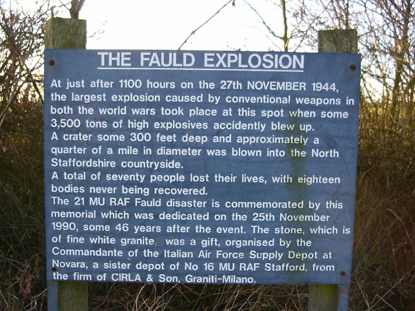
After passing through Draycott and Hanbury, you can't miss the crater of the Fauld explosion, or at least signs telling you not to go any further or be blown up. You'll see from the map that the public footpath follows the circumference of the crater. A high fence protects you from the unexploded bombs.


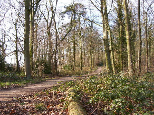
This is the best picture that I managed to take of the crater. It really doesn't show the hugeness of the hole, but you can see the tops of very tall trees which are growing in the bottom of the crater. The sign tells the story better than I can.


The route and distance statistics above were generated using Meander.

Image produced from the Ordnance Survey Get-a-map service. Map image reproduced with kind permission of Ordnance Survey and Ordnance Survey of Northern Ireland.