Showing posts with label Leicstershire Round. Show all posts

Thursday, April 05, 2007

Ivanhoe Way (part of) (part 3)

  • Walked: 1st April 2007.
  • Distance: 12 miles
  • Total time 5 hrs
  • Terrain: some inclines
  • Summary: circular walk starting from Odstone, through Nailstone and Bagworth, and around in a circle.
  • map: Explorer 245
  • Nature Watch: More trees are starting to show signs of life, and we spotted two butterflies, a red admiral and a bright yellow one, which did look a bit bewildered in a 'where is everyone' kind of way. Even at this early stage in the season, the ground seems parched and cracked.


We fancied a decent Sunday afternoon walk (less than 15 miles) and I wanted to continue my fragmented offensive on the Ivanhoe Way. Starting at Odstone (where I left off last time) and continuing for several miles, around in a circle; the route planned itself. For something with such little planning, this was a really pleasant walk.

Maybe this was a particularly exposed route, or maybe it was particularly windy, but I did find myself (more accurate to say that Roger pointed out that I was) compaining a lot about the persistent and annoying strong breeze.

The first part of this walk is once again part of the Leicester Round as well as the Ivanhoe Way, but be aware that the wayposts only tend to only mention the former. However, the paths were good and pretty easy to follow.

This is the unusual tower / spire at Nailstone.


The Ivanhoe Way / Leics Round are a bit difficult to follow here, they disintergrate into a number of small footpaths through Nailstone. The idea is to walk around the back of the church through the beautifully-kept graveyard and cross a road to pick up the IW / LR. Across some fields, and we find this very new piece of National Forest - so new that there aren't actually any trees, but this polo-shaped pond will be nice when there are things growing around and in it. There's a bit of a hill to climb here, but the view from the top is far and wide and beautiful.


We go through Bagworth, which although conjouring up images of a major with a curled handlebar moustache and a shotgun over his arm, is a rebuilt mining village and feels depressingly like a dormitary. The other side of Bagworth, the Ivanhoe Way passes under a railway line via this pretty bridge.


Today we left the Ivanhoe Way at the Quarry - this isn't the same one that you look into from the top of Bardon Hill (see Leicestershire 3 Peaks) but is close by, just the other side of the A511. I enjoyed this beautiful piece of PR - a tree recognition chart, which tells you about all the wonderful trees they've planted to screen off the quarry.


And here we have the enormous hole in the ground:


From here we have a wonderful view of Billa Barra with its crown of trees at the top - again see Leicestershire 3 Peaks:


Having left the quarry and crossed a road, we walk alongside a railway and eventually cross it. I can't believe it's possible to walk across the tracks with nothing more than a 'be careful' sign. Even though you can see a long way, you really do feel pretty vulnerable when you're half way across.


This is one of the nicest bits of National Forest we've seen. The trees are particularly well-developed, and now really starting to green up. Signs mentioned a 'Birthday Walk' (I guess 10 years of the NF?) - a 10-mile route. Note to self - investigate this further.


And this, I guess, is the end product of the National Forest. it's nice to see that it's being harvested already.


Image produced from the Ordnance Survey Get-a-map service. Map image reproduced with kind permission of Ordnance Survey and Ordnance Survey of Northern Ireland.

Friday, March 30, 2007

Ivanhoe Way (part of) (part 2)

  • Walked: 28th March 2007.
  • Distance: 8.7m
  • Total time 3 hrs
  • Terrain: fairly flat with a slight climb
  • Summary: circular walk starting from Snarestone, to Odstone and Swepstone.
  • map: Explorer 245
  • Nature Watch: hedges are still in the middle of 'leafing up', very few trees are making the effort yet. More flowers are showing themselves. Some winter crops of rape seed are just flowering, turning some patches of Derbyshire and Leicestershire bright yellow.


This evening was the first time this year that it's been possible to go walking after work (without a torch), and the first time that the weather was pleasant enough to give that very contented feeling. Mmmm.


This walk continues my efforts to walk parts of the Ivanhoe Way ahead of doing the whole walk in one day later in the year. It starts at Snarestone, which is the spot I parted company with the Ivanhoe Way last time out. I followed the IW to Odstone before heading off towards Swepstone and forming a circle back to Snarestone.

The first km from Snarestone crosses some pleasant meadows, before 'dog legging' across a lane. Then some more fields before joining a road. It's a very quiet and pretty road, though.


Looking around I was struck by how flat this part of the country can be. Unusually for Leicestershire, the next stile is not very easy to spot - it's there to the right of the picture:


Once over that stile, the path joins the canal. I love canal towpaths! They're beautiful, flat and good underfoot.


Just a short stretch of this brings us out on another road, where I had planned to leave the Ivanhoe Way.

My big mistake of the evening was to leave the IW here. I did so because it disappears off the bottom of the map that I had with me (Explorer 245), and while Leicestershire is fantastic with its maintenance of its yellow waymarkers and fingerposts, I wouldn't trust to those without a map. The shortcut I took, which was both marked on the map and signposted with a green fingerpost, crossed a field of horses with an electric fence across the entrance and exit. I'm very cautious with these now (see traumatic experience 2 or 3 posts ago), and so did some deft limbo'ing on one side, and careful straddling the other. I then had to climb over a fence (thanks Mr Landowner) and through a farmyard and very muddy path before picking up the good path which is shared by the Ivanhoe Way and Leicestershire Round. (Note to Self - stick to Ivanhoe Way here, and write to Leicestershire CC about the electric fence!)

There then followed quite a climb, but the view from the top of this hill is quite something. This evening was very pleasant, but a little misty, and so the views were spoiled a little.


The villages Odstone, Newton Burgoland and Swepstone are all very pretty and idyllic. This walk passes through all 3 by road, but again, it's a quiet road with verges in places.


There is something particularly appealing about Swepstone Church. what makes it better still (I went to a Christening there recently) the minister is Patrick Stewart (or perhaps a lookalike). I passed this Church during the last walk, and this time I picked up the same path and followed it back to Snarestone.


The stats and route below were generated with Meander.


Image produced from the Ordnance Survey Get-a-map service. Map image reproduced with kind permission of Ordnance Survey and Ordnance Survey of Northern Ireland.

Wednesday, September 27, 2006

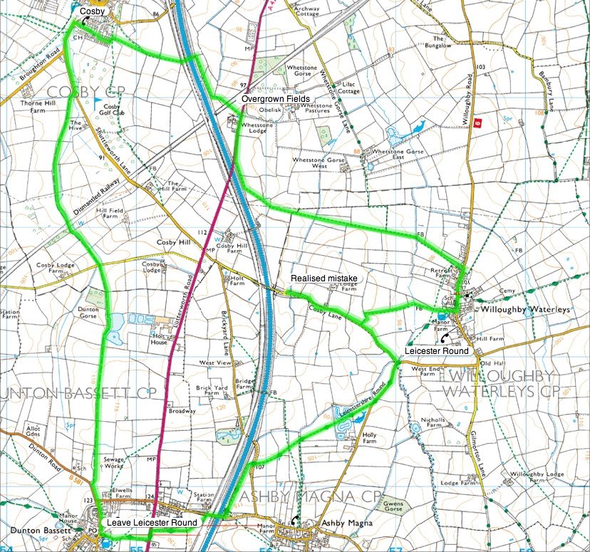
Leicestershire Round (Willoughby)

  • Walked: 24th September 06
  • Distance: 8.6m
  • Terrain: flattish
  • Summary: Park at Willoughby Waterleys, pick up the Leicestershire Round path, Follow through to Dunton Bassett, then a bridleway to Cosby, back to Willoughby.
  • Time: 4 hrs
  • Notable views: a bit flat to afford long views, but some nice ones between Dunton Bassett and Cosby
  • Note to self; take camera next time!

I discovered a few weeks ago the Leicestershire Round and how pleasant some parts of the county are, and promised myself I'd go back and investigate further.


you'll see from the map below that we immediately went astray and had to backtrack a little! I had no idea just how noisy a motorway is - you can hear it from a coule of fields away. However, walking underneath the motorway bridge (just east of Cosby) was a fascinating experience; the very loud traffic noise just disappears as you walk beneath the road, and then returns as you get back out into the open!


The long, straight bridleway is very pleasant indeed, easy to walk, easy to follow and has some lovely views.


The route above was generated using Meander.

Image produced from the Ordnance Survey Get-a-map service. Map image reproduced with kind permission of Ordnance Survey and Ordnance Survey of Northern Ireland.