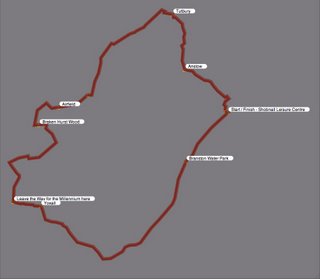
- Walked: 29th August 06
- Distance: 26m
- Terrain: fairly flat
- Summary: starting from Shobnall, follow Millennium Way along the Trent and Mersey canal and through to Yoxall. Leave the MW and take footpaths to Braken Hurst Woods, pass the airfield and head north, skirt south of Tutbury and back to start point via Anslow.
- Time: 11 hours start to finish, 9hours walking, 2hours stop time (according to Garmin)
- Notable views: View over Burton from SK229244; the view all the way across to Ratcliffe power station from Hanbury and Tutbury; Anslow is a really pretty village
- Notes to self: write to Staffs County Council about the impassable dead end at SK130197. Next time allow more time and investigate the crater at Hanbury (183277). Next time don't wear shorts as some of the paths are not well-trodden.
What could be a better way to spend an August bank holiday monday than covering 26 miles of Staffordshire? (Midlands, UK). The title given to this walk relates more to the time of year than the geography of the route - we probably managed the government's 5-a-day for the next month - the total bounty included Damsons (a delicious small blueish plum), mushrooms (I was very dubious to start with, but I'm still alive, and picked straight off the ground they were tastier and better-looking than shop-bought ones), apples (a bit sour), walnuts (not quite ripe and not eaten on route!), hops (interesting to see how bitter gets its bitter taste!), sloes (not really edible, but great for making sloe gin) and of course blackberries, which were permanently within reach.
Showers were a little bit more plentiful than the bbc had led us to believe, but our reward came near the end of the walk in the shape of the strongest most spectacular rainbow I've ever seen, like some kind of divine finishing post!!

The route above was generated using Meander. I'm heistant to publish the route complete with the map because of Ordnance Survey's licensing, but if you'd like the route superimposed on the OS map as a jpeg or in Meander file format, just email me.
