
Saturday, November 13, 2010
Betws-y-Coed circular walk
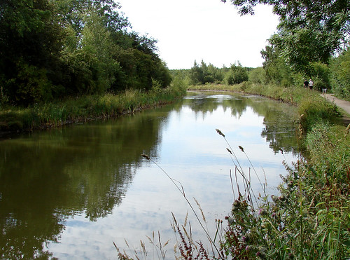
While in Wales last month I had an afternoon on my hands, sunshine in the sky and some beautiful scenery around me. I devised this short circular walk to stretch the legs ahead of the climb up Tryfan the next day.


Monday, November 01, 2010
the walking year
You won't have failed to notice that as I've walked I've snapped away, posting many of the photos here, facebook and flickr.
If you've enjoyed the photos, why not have printed copies to put on your wall and support uk-walks.info at the same time? Each page features a main image with some inset pictures of things growing and living in the countryside to try and spot at that time.
The calendar is 2011 month to view with preview of 2012. Here are a few of the images, you can see a slideshow of all 12 at http://uk-walks.info/walking-calendar.html


Thursday, October 28, 2010
Tryfan Circular Walk
Distance: 5m
Walked: 25 Oct 2010
Terrain: climb to 900m with scrambling
In Wales for something completely different, the weather looked so good on Monday that I decided to stay and walk.
Tryfan is just about 3,000ft (916m) and not for the faint-hearted or inexperienced. I've climbed it once before but I'd forgotten how difficult it is. At times I thought I'd made a mistake trying to go up alone, but the sense of achievement was amazing.
The walk starts by the beautiful Llyn Ogwen. A very still and sunny day today hence the lovely reflections.

I decided to use the heather terrace to climb it, this is the most gentle way up, although close to the top it's impossible to finish without scrambling (climbing over or up rocks using all four limbs).


I've not dared to jump from Adam to Eve (or vice versa) but have seen others do it. It's 3,000ft up and the summit is steep, particularly in one direction, so after a missed landing mountain rescue could be picking up the pieces.

I chose another way down, past Llyn Bochlwyd. Again, the views were amazing, although tainted slightly by pain from the legs; briuses and scrapes as well as aches.


Saturday, October 16, 2010
Curbar Edge and Froggatt Edge in the autumn
Walked: 16/10/10
Distance: 9 miles
Terrain: good surfaced paths, climb to 340m
This walk has some superb views and is easy walking.
Today was a mixed bag weatherwise but fortunately the sun came out over the most gorgeous views.
There's an option at SK255775 of turning around and retracing your steps, or nipping down into the Derwent valley and using the Derwent Valley Heritage Trail for the return loop. The latter is well-signed and it's enjoyable to see above you the silhouette of the edge you've just walked.


Thursday, September 16, 2010
Ivanhoe Way Challenge 2010
Distance: 35miles
Walked: 15 Sept 2010
Very proud of myself today (and a little sore) after completing the Ivanhoe Way in less than the challenge time.
I started at 6am, just as the sky was getting light, finished at 6:40pm - that's 12hrs 40mins, well under the challenge time of 15 hours. Includes a 35min lunch stop, and various very short stops.


All photos from today are at http://www.flickr.com/photos/shieladixon/sets/72157624845072143/
Wednesday, August 18, 2010
Rutland Water Egleton Circular Walk
Walked: 15 August 2010
Distance: 5.5m
This is a very pretty walk, devised last year while trying to find high views over the reservoir. Today was reasonably sunny, but hazy in the distance, meaning that the long photos aren't quite as spectacular as they could be.
I saw lots of these minibeasts this morning, looking at first glance a bit like something an animal has left behind. I think they may have been looking around for something that an animal has left behind. Very shiny and black, with a little bit of irridescence, similar to the classic scarab beetle.


Sunday, August 08, 2010
Ivanhoe Way (in two halves)
Distance: 36m
Walked: 7th & 8th August 2010
Not feeling quite ready to take the challenge for this year (that's the full 36m in less than 15 hours) I decided a good training exercise would be to do the full loop in two halves, with a sleep in between.
I live virtually on the route, so I drove my car to the furthest point from home - Stanton-under-Bardon so that I could walk half the distance, have tea and sleep, then finish the walk and finish at my car.
I didn't get as many photos as I could have because a few miles in on the first day I thought my camera had packed up. It turned out that the batteries I'd bought in an emergency on the way to the start were useless for anything other than remote controls.
Lots more photos are here at Flickr
More information about the Ivanhoe Way
Sunday, August 01, 2010
Rutland Water with Peninsula
Walked: 31/7/10
Distance: 20-something miles (or 14 without peninsula loop)


More photos of today's walk at http://www.flickr.com/photos/shieladixon/sets/72157624499826137/


Distance: 20-something miles (or 14 without peninsula loop)


More photos of today's walk at http://www.flickr.com/photos/shieladixon/sets/72157624499826137/


Monday, July 26, 2010
early blackberries
Walked: 25/7/10
Distance 5m
Yes it's true, on 25 July, I found ripe blackberries.

With just a couple of hours to spare, I needed a short walk with a start close to home. This walk starts and finishes at the Beeches pub in Ashby, passes the Tap House (used to be Anwell Inn), crosses the A511, past the Bluebell Arboretum, through Smisby and past the Smisby Arms, takes in some beautiful views just north of Ashby and returning via the Ivanhoe Way.

And yes, they were delicious!
More photos from this walk on Flickr
Click the map below to view it at OS Explore
Thursday, July 22, 2010
Spring in full bloom
Walked: 23 May 2010
Distance: 11m


More photos from this walk are here on Flickr
The route is below. For the most detailed 1:25,000 map, buy Explorer 245, The National Forest

Distance: 11m


More photos from this walk are here on Flickr
The route is below. For the most detailed 1:25,000 map, buy Explorer 245, The National Forest

Saturday, July 10, 2010
My new heroine
From now on, the Gore-Tex stays at home. Like Mary Henrietta Kingsley I'm going to adopt Victorian formal-wear for walking including corset, good thick skirt and sensible shoes.
Animal-traps, crocodiles and cannibals held no fear for this English lady as she explored Africa clad head to foot and straight-backed.

Read more about this Great British Nutter here:
http://greatbritishnutters.blogspot.com/2008/04/mary-kingsley-friend-of-cannibals.html
Animal-traps, crocodiles and cannibals held no fear for this English lady as she explored Africa clad head to foot and straight-backed.
Read more about this Great British Nutter here:
http://greatbritishnutters.blogspot.com/2008/04/mary-kingsley-friend-of-cannibals.html
Thursday, July 08, 2010
Trent and Mersey, Wilson to Willington Circular
Walked: 8/7/10
Distance: 17m
Route: http://explore.ordnancesurvey.co.uk/os_routes/show/17744


As my photos have become more important in my posts, I've decided to make more use of Flickr. (Sorry, Blogger)
All photos from this walk are here:
http://www.flickr.com/photos/shieladixon/sets/72157624453181190/
Distance: 17m
Route: http://explore.ordnancesurvey.co.uk/os_routes/show/17744


As my photos have become more important in my posts, I've decided to make more use of Flickr. (Sorry, Blogger)
All photos from this walk are here:
http://www.flickr.com/photos/shieladixon/sets/72157624453181190/
Saturday, May 01, 2010
Dawn Chorus Walk
I'm really not a morning person, so it takes something special to get me up at 4am. I've never really been a bird person either, other than enjoying birdsong as background noise.
The Dawn Chorus Walk run by the Environmental Education Project at Rosliston Forestry Centre was a real eye-opener (ear-opener?). Here's a taster of what we were listening to at about 5:30
Dawn Chorus 1 May 2010 | Music Codes
A chap called Dave led us around the site telling us about the songs that we were listening to. It's amazing that once a particular song has been explained to you, you can pick it out from the general cacophany. Also amazing that once you can recognise a particular bird's song, you can then 'spot' that bird from its call alone, tell roughly where it is, and then maybe even see it.
The dawn chorus itself is something special. Each bird has its own special song, but when put together they make a fascinating piece of music with random elements.
I'm very pleased to have experienced it, and to have seen such a wonderful sunrise.


The Dawn Chorus Walk run by the Environmental Education Project at Rosliston Forestry Centre was a real eye-opener (ear-opener?). Here's a taster of what we were listening to at about 5:30

Dawn Chorus 1 May 2010 | Music Codes
A chap called Dave led us around the site telling us about the songs that we were listening to. It's amazing that once a particular song has been explained to you, you can pick it out from the general cacophany. Also amazing that once you can recognise a particular bird's song, you can then 'spot' that bird from its call alone, tell roughly where it is, and then maybe even see it.
The dawn chorus itself is something special. Each bird has its own special song, but when put together they make a fascinating piece of music with random elements.
I'm very pleased to have experienced it, and to have seen such a wonderful sunrise.


Tuesday, April 27, 2010
Packington / Normanton
- Walked: 23 April 2010
- Distance: 5.5m
- Terrain: flattish
- Summary: Park in packington, cross fields to Sprng Lane and continue straight along track. Take the muddy bridleway to Normanton le Heath, and take paths which run parallel to the road back to Packington.
- Time: 2 hrs

The weather's been so nice recently, so the muddy bridleway wasn't. A beautiful afternoon, with lots of signs of spring around; various shades of green in the trees and hedges, blackthorn flowers, dandelions in full flower, elder starting to come into leaf, lambs in the fields.


The route above was generated using Meander.
Image produced from the Ordnance Survey Get-a-map service. Map image reproduced with kind permission of Ordnance Survey and Ordnance Survey of Northern Ireland.
Subscribe to:
Posts (Atom)

