Sunday, April 29, 2007

South Wood Bluebell Walk

  • Walked: 6th April 2007
  • Distance: 6.7m
  • Terrain: 90m ascent over 3 miles and the same descent
  • Summary: Walk through Dimminsdale Nature Reserve, South Wood, Ashby by-pass, back to start along Ivanhoe Way
  • Time: 2.5 hours start to finish

The objects of the exercise tonight, other than the usual training and familiarisation for the Ivanhoe Way, were to capture some bluebells on film (or CCD, I guess) and to see if I could spot some Hawthorn in early flower. There are a number of places where the 'carpet of blue' effect is apparent at this time of the year, but I couldn't remember exactly where my best chances were. Therefore I set off on the route below in fading light and with my fingers crossed.

Very close to the Dimminsdale Reserve is a convenient car park. Just before walking into the woods, you get this lovely view of the bottom of Staunton Harrold Reservoir.


Even though the half-way point of this route is close to my house, I drove out to this point in order to get (I thought) the best chance of seeing Bluebells while the light was still good. Unfortunately, the nature reserve didn't yield great numbers of bluebells, there were plenty of other lovely things to see such as wild garlic in flower, and lots of blossom.


South Wood is a route between Ashby and Staunton Harrold which is popular with walkers and runners. I first spotted these curious 'albino' bluebells!


And Bingo, here I found the carpet of blue that I was looking for:


After emerging from the wood, and crossing a couple of fields, we meet the Ashby by-pass. This road was very good for the town, taking the heavy through traffic from the town centre. It cuts through some of the most beautiful countryside in the area, and so walking alongside it is a bitter-sweet experience - you have the unsightly tarmac and traffic noise, but it does afford some of the longest and most beautiful views.


And here's the money-shot! it was here that I saw hawthorne in flower. This picture was taken on 26 April 2007.


I have a clear memory of my maternal grandmother telling me that her two christian names, Violet and May, were both the names of flowers. She explained that May was a flower which grows on hedgerows. I now know that it's another name for the Hawthorn flower, which is so named because it appears in May. She wouldn't have known at the time that thirty years on, we would be citing the early appearance of these flowers as a symptom of the fact that the very planet we live on is being screwed up by vast overpopulation and the tendency for people to jump onto aeroplanes as if it were a bus ride.

This walk then picks up the Ivanhoe Way which goes all the way back to Dimminsdale. I love this part of the Ivanhoe Way, possibly largely because it's a very long downhill, but partly because it's very beautiful. As planned so far, my Ivanhoe Way attempt would bring me along this path in the opposite direction at the very end of the 36 miles. I considered whether I really wanted to finish the walk in this way, and have decided to reverse my original plan and walk the route in the opposite direction (ie the direction that Rog considers the correct direction). This new plan means that I'd start my attempt on the long walk with this long downhill and its lovely view, and take in Dimminsdale in the early morning.


The route above was generated using Meander.

Image produced from the Ordnance Survey Get-a-map service. Image reproduced with kind permission of Ordnance Survey and Ordnance Survey of Northern Ireland.

Thursday, April 26, 2007

Ice axe, rope and a fantastic Edwardian moustache

I haven't yet written a post here which doesn't relate to a walk, but I just have to record these images from this month's Trail magazine.

It's surprising to find that rock climbing started so recently. The rocks have been there for millennia, but it was only a hundred years or so ago that someone had the bright idea of tying themselves together with a rope as an aid to getting to the top. They hadn't thought of hammering little eyelets into the rock and threading the rope through at that point, apparently being British, they just relied on the principle: 'The leader never falls'.


You might think these gents (above) have put on their best suits especially for the photo, but no. Presumably the fellows in the picture below are wearing their second-best tweed suits, but 3-piece whistles they are indeed wearing. No doubt calling each other 'old chap' and sparking up a pipeful of St Bruno once on the summit.


If you love all of this as much as I do, then please buy and read a copy of 'The Ascent of Rum Doodle'.

Monday, April 09, 2007

Brecon Beacons

It tested my faith in Rog (or my gullibility) when he suggested going to one of the most famous and stunning parts of the country on an unseasonably pleasant holiday Sunday, walking a path known as the "popular route" and asserting that there wouldn't be anyone else around. He admitted later that there were more people than he'd expected.

The walk started beautifully - just as many people around as I like (none).


From the place where we parked, we had a mile or so along a small road and then another couple of miles along a track, which turns out to be a popular cycle route, but at this stage in the morning, we were pretty much alone. The main part of this walk follows ridges and a number of peaks.


The real work started at a place known as The Gap between Fan Y Big (yes really) and Cribyn (which we immediately cristened Bernard). The picture above shows the gap (centre) and Bernard (left).


Elevenses half way up Bernard with a beautiful view of Fan Y Big (above) helped us on our way, and then a couple of false summits saw us at the top of Bernard. (below)


The next peak is Pen Y Fan, the highest peak in South Wales. What I really learned today is how different the profile of the land looks from different viewpoints. At the start of the walk, the ascent to Pen Y Fan looked vertical. However, from the top of Bernard, looking almost 'sideways on', we could see our path gently climbing to the top.

Before ascending to the highest peak, we had quite a descent to make. If you've never done it, you won't believe it, but losing 200 metres is harder than climbing the same. You use muscles in your legs that really don't get much use, and you very quickly get the wobbly legs. I discovered this in Wales last year, and had not been up and down mountains this high since then.

The climb to Pen Y Fan was reasonably gentle and I christened this one Shielopolis - partly because of the very blocky, architectural rock formations, and partly because of the large population we found up there. In the pictures below we're sitting on top of Pen Y Fan, looking away from the crowd. Yes, that's me, and it's the first time that I've had my legs on show this year. I highly recommend the kind of walking trousers that have zip-off legs - You're able to start in the morning with full trousers on, unincumber yourself when the sun is warm enough, but have those trouser legs handy in case of undergrowth or cool spells.


Up until now, we'd only really seen a few people. Getting to the top and seeing so many people really was quite bizarre.

I immediately decided that there must be a car park nearby. Rog was a little more charitable, suggesting that I give these people the credit they deserve for making the climb, but I really couldn't belive that there wasn't a car park 100 yards away. People shouting into mobile phones, young families, hundreds of dogs, chavs in track suits and trainers, enough new-lookng walking gear to stock several branches of Black's, jelly bellies, even a new baby in someone's arms. All of the signs were there.

This continued to be the case along the path to Corn Du, which looks from a distance like a 'mirror image' slightly smaller twin of Pen Y Fan. From here we could see two paths up / down being very heavily used - from high up these paths looked like two lines of coloured ants.

This picture is looking (again, away from the people) over a Cwm called Llyn Cwm Llwch.


Checking out an article in Trail Magazine later (May 2007 p118) filled in the details. 2.5 kms away are two car parks and the Storey Arms Centre. The paths are known as the Story Arms Path and Trail Magazine notes "Extremely popular path best avoided at holiday times or weekends". Don't believe anyone that tells you otherwise, as I did.

A little further on, and we were once again reasonably alone. We walked along a Craig, or ridge, scarily steep on one side, and gentle on the other.


All along this 'leg' of our horseshoe walk, we could clearly see the entire path that we had already taken. We stopped at a trig point to finish off our coffee. This is the first trig point that I've seen with a memorial plate attached. The peaks climbed earlier are behind the trig point in the distance. Notice how yellow / brown the ground is. The grass really did look thirsty, and the reservoirs that we could see down below were obviously much lower than they have been.


A very short but steep descent later and we were back at the level we'd started and less than a couple of miles away from the start.


The route and stats above were generated using Meander. The profile was generated using Tracklogs.

Image produced from the Ordnance Survey Get-a-map service. Image reproduced with kind permission of Ordnance Survey and Ordnance Survey of Northern Ireland.

Swarkestone Causeway

  • Walked: 6th April 2007
  • Distance: 5m
  • Terrain: very flat
  • Summary: Stanton by Bridge, Cloud Trail, Trent and Mersey, Swarkestone and back along the famous causeway
  • Time: 2 hours start to finish

This walk starts at the lower end of Swarkestone Causeway - a very pretty village called Stanton by Bridge. Walk away from the causeway using a track which itself is very pleasant and affords some woderful views. Few hedges now have to show some signs of life, and so the hedgerows are varying shades of green and white.


This sign points to the Holy Well. I'll not say any more - if you're curious, go down the steps and see whether the visit was worth the trouble.


We take a footpath to the left, just after the Holy Well and just before the track ends at Kings Newton. We cross some fields to join the cycle path known as the Cloud Trail.

The cycle path crosses the Trent (above) and a little further on joins the Trent and Mersey Canal (below). I love canal towpaths.


Name the album? A famous band posed in front of this very strange building for one of their album covers.


We leave the canal just after seeing this building. Crossing a copule of fields brings us to the bridge at the top end of Swarkeston causeway. A most attractive spot. Just the other side of this bridge is the Crewe and Harpur pub, which has good beer, a large beer garden (with a view which is just as good as this one) and is friendly to bikers and walkers.


I have no idea what this yellow flower is, but it was growing in a hedge.


Here is a view of the causeway which drivers will usually miss. It carries a stretch of road above a flood plain and is an ancient monument. It's narrow and busy, so not suitable for walking along, but luckily there is a public right of way to the side of it on the same side as the Crewe and Harpur. You have to cross the bridge, and then take the road to the right (marked Ingleby), into the Sailing Club driveway and through a farm gate. Then you can walk along it with this unusual perspective on it. We looked for trolls, but didn't see any!


The route above was generated using Meander.

Image produced from the Ordnance Survey Get-a-map service. Image reproduced with kind permission of Ordnance Survey and Ordnance Survey of Northern Ireland.

Friday, April 06, 2007

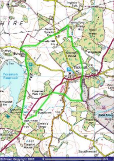
Ticknal Circular (in reverse)

  • Walked: 4th April 2007
  • Distance: 6.5m
  • Terrain: fairly flat
  • Summary: Hartshorne to Ticknall, Calke Abbey and walk the length of Foremark Reservoir using the straight bridleway
  • Time: 2 hours start to finish
  • Notable views: View over the Trent Valley after Ticknall.


This is one of my most regular after-work walks. Last time I made a note to myself to try this in reverse (finish - start, not walking backwards!) I tried that this time, but still kept turning around to take photos, so I'm not sure what the moral of the story is. Either way, I did get a lovely surprise at the end.

Starting from the layby at the bottom end of Foremark Reservoir, paths across fields take you to Ticknall, with some wonderful views like this one:


Seeing a ploughed field is always a heart-sinking thing - they're usually horrible to cross, but look at this! The farmer has either ploughed around the path, or compressed it afterwards. it's the first time I've seen this done, and it's wonderful.


Across the Ahby-Ticknall road, and we cross a few more fields to get to the Calke estate.


I don't think these fellas are many days old.


Calke Park has some wonderful old gnarly trees.


Leave the park, cross the road, and head in a pretty straight line through some National Forest. The Trent Valley opens up in front of you here, which is a lovely view on a clear day. We pass a fishing pond, Seven Spouts Farm and Hangman's Stone before crossing a roadand walking up the driveway to Foremark Res. There's a very straight bridleway along the side of it, and I hadn't realised that I'd see the sun setting over the water. It was a very nice end to the walk.


The route above was generated using Meander.

Image produced from the Ordnance Survey Get-a-map service. Image reproduced with kind permission of Ordnance Survey and Ordnance Survey of Northern Ireland.

Thursday, April 05, 2007

Ivanhoe Way (part of) (part 3)

  • Walked: 1st April 2007.
  • Distance: 12 miles
  • Total time 5 hrs
  • Terrain: some inclines
  • Summary: circular walk starting from Odstone, through Nailstone and Bagworth, and around in a circle.
  • map: Explorer 245
  • Nature Watch: More trees are starting to show signs of life, and we spotted two butterflies, a red admiral and a bright yellow one, which did look a bit bewildered in a 'where is everyone' kind of way. Even at this early stage in the season, the ground seems parched and cracked.


We fancied a decent Sunday afternoon walk (less than 15 miles) and I wanted to continue my fragmented offensive on the Ivanhoe Way. Starting at Odstone (where I left off last time) and continuing for several miles, around in a circle; the route planned itself. For something with such little planning, this was a really pleasant walk.

Maybe this was a particularly exposed route, or maybe it was particularly windy, but I did find myself (more accurate to say that Roger pointed out that I was) compaining a lot about the persistent and annoying strong breeze.

The first part of this walk is once again part of the Leicester Round as well as the Ivanhoe Way, but be aware that the wayposts only tend to only mention the former. However, the paths were good and pretty easy to follow.

This is the unusual tower / spire at Nailstone.


The Ivanhoe Way / Leics Round are a bit difficult to follow here, they disintergrate into a number of small footpaths through Nailstone. The idea is to walk around the back of the church through the beautifully-kept graveyard and cross a road to pick up the IW / LR. Across some fields, and we find this very new piece of National Forest - so new that there aren't actually any trees, but this polo-shaped pond will be nice when there are things growing around and in it. There's a bit of a hill to climb here, but the view from the top is far and wide and beautiful.


We go through Bagworth, which although conjouring up images of a major with a curled handlebar moustache and a shotgun over his arm, is a rebuilt mining village and feels depressingly like a dormitary. The other side of Bagworth, the Ivanhoe Way passes under a railway line via this pretty bridge.


Today we left the Ivanhoe Way at the Quarry - this isn't the same one that you look into from the top of Bardon Hill (see Leicestershire 3 Peaks) but is close by, just the other side of the A511. I enjoyed this beautiful piece of PR - a tree recognition chart, which tells you about all the wonderful trees they've planted to screen off the quarry.


And here we have the enormous hole in the ground:


From here we have a wonderful view of Billa Barra with its crown of trees at the top - again see Leicestershire 3 Peaks:


Having left the quarry and crossed a road, we walk alongside a railway and eventually cross it. I can't believe it's possible to walk across the tracks with nothing more than a 'be careful' sign. Even though you can see a long way, you really do feel pretty vulnerable when you're half way across.


This is one of the nicest bits of National Forest we've seen. The trees are particularly well-developed, and now really starting to green up. Signs mentioned a 'Birthday Walk' (I guess 10 years of the NF?) - a 10-mile route. Note to self - investigate this further.


And this, I guess, is the end product of the National Forest. it's nice to see that it's being harvested already.


Image produced from the Ordnance Survey Get-a-map service. Map image reproduced with kind permission of Ordnance Survey and Ordnance Survey of Northern Ireland.