Sunday, November 30, 2008

Early winter nature watch

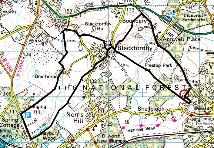
Route: Blackfordby figure-of-8
Walked: 30 November 2008
Distance: 8m
Summary: Starting at the Heart of The National Forest, Ashby de la Zouch, walk to Blackfordby, continue out to Woodville, then back in a loop to Blackfordby and a different Route back to Ashy (Possibly starting and finishing at The Beeches pub, well worth a swift visit).

I've broken a bit of a lull in my walking and made the most of the glimmer of sunshine which made it through the dull sky.

We're just three weeks away from the winter solstice, which here in the northern hemisphere means the days are almost as short as they're going to get. This, combined with me being short of spare time and letting my fitness lapse a bit, means that a shortish walk starting and finishing at my house was the order of the day.

I've written about my Blackfordby figure-of-8 walk before. It's one of my most regular South Derbyshire walks. The distinctive broach spire of Blackfordby church is in view most of the time. Today the church was looking a bit green and mossy.


In another life I'm bracing myself for Christmas Caroling season. It's not quite the bleak mid-winter yet, but 'The Holly and the Ivy' did seem very appropriate today. On the whole the trees and hedgerows looked pretty lifeless, but a few things were still keeping vigil, or in one or two cases, just coming into their own. Ivy looks pretty healthy and its berries are just starting to appear:


There's quite a contrast here between the brown and brittle bracken (to the left of the path) and the thriving holly on the right:


Surprisingly there are still plenty of red berries, including rosehips. These ones are among brambles (the blackberry bush) which are still green, but looking very tired and yellowing:


This bush was heaving with red rosehips, and looking really interesting, I thought, in silhouette against an attractive winter sky.


The route above was generated using Meander.

Image produced from the Ordnance Survey Get-a-map service. Map image reproduced with kind permission of Ordnance Survey and Ordnance Survey of Northern Ireland.

Saturday, October 04, 2008

Hadrian's Wall

[Brian is writing graffiti on the palace wall. The Centurion catches him in the act]
Centurion: What's this, then? "Romanes eunt domus"? People called Romanes, they go, the house?
Brian: It says, "Romans go home. "
Centurion: No it doesn't ! What's the latin for "Roman"? Come on, come on !
Brian: Er, "Romanus" !
Centurion: Vocative plural of "Romanus" is?
Brian: Er, er, "Romani" !
Centurion: [Writes "Romani" over Brian's graffiti] "Eunt"? What is "eunt"? Conjugate the verb, "to go" !
Brian: Er, "Ire". Er, "eo", "is", "it", "imus", "itis", "eunt".
Centurion: So, "eunt" is...?
Brian: Third person plural present indicative, "they go".
Centurion: But, "Romans, go home" is an order. So you must use...?
[He twists Brian's ear]
Brian: Aaagh ! The imperative !
Centurion: Which is...?
Brian: Aaaagh ! Er, er, "i" !
Centurion: How many Romans?
Brian: Aaaaagh ! Plural, plural, er, "ite" !
Centurion: [Writes "ite"] "Domus"? Nominative? "Go home" is motion towards, isn't it?
Brian: Dative !
[the Centurion holds a sword to his throat]
Brian: Aaagh ! Not the dative, not the dative ! Er, er, accusative, "Domum" !
Centurion: But "Domus" takes the locative, which is...?
Brian: Er, "Domum" !
Centurion: [Writes "Domum"] Understand? Now, write it out a hundred times.
Brian: Yes sir. Thank you, sir. Hail Caesar, sir.
Centurion: Hail Caesar ! And if it's not done by sunrise, I'll cut your balls off.

Distance of this circular walk: 7m
Walked: 27 September 2008

If there was any graffiti on Hadrian's Wall, which bounded the far corner of the Roman Empire, then it's long gone. As is the vast majority of the wall itself.

I have to take my hat off to the tourism people responsible for marketing the area, for getting so much value from something long gone. It's not fair to say that it's not there any more, because there are visible signs, but you have to look for them. On arrival at Greenhead near Gilsland (near Carlisle) I saw big letters on the side of a bus saying 'Hadrian's Wall Country'. It does all lead you to believe that there's a wall there to see and walk along.

To be fair, it's a well marked route, with plenty of information boards and bits and pieces to see and some glorious English countryside. I had just been expecting to see a wall - that's all!

Our starting point was close to Thirlwall Castle. Built long after the romans had gone, out of stones robbed from the wall itself, it's a fascinating piece of history. It marks a time of conflict, not between the Romans and those just beyond their empire, but between the Scots and English.


This route took us north-east; away from the route of the wall, but through some gorgeous scenery. The weather had looked dodgy (at best) when we set off, but as you can see it was superb for most of this walk.


Having turned south to join the river, footpaths took us back to Gilsland and the route of the wall. Our first sign of the wall was Poltcross Burn Milecastle, accommodation for about 60 soldiers or possibly prisoners. There's not much left, but the information boards show how (we think) it looked. The wall extended east and west from here.


This awesome arch, straight out of Lara Croft, is much later. The railway line runs over it.


This is what's left of the wall itself in this area. A bit of a mound and a bit of a ditch. Interestingly, you're asked not to walk in single file or worn bits of ground as an erosion measure. It's easy to see why a ditch and a mound like this is a good defence measure and puts those beyond it at something of a disadvantage. Even without the wall, it would be quite difficult to scramble over this lot with your sword in your hand and an enemy throwing things at you.

Sunday, September 21, 2008

Rutland Water - with peninsula!

Distance: 21 miles
Walked 20 September 2008


The last time I walked around Anglia Water's 3100 acre reservoir (the largest man-made lake in western Europe, folks) I didn't have time to walk the optional loop around Hambleton Peninsula.

Today I did, and it was a fascinating experience. You'll see from the maps at the bottom of this post that the reservoir is a U shape. You can just walk a circle around the outside, or you can add the inner circle. I walked anti-clockwise around the outside, and had walked almost all of the outer circle before arriving at the peninsula, so while still keeping the water's edge on my left, I found myself changing direction and walking clockwise, and seeing all of the paths already trod, across a stretch of water.

Today we're in the middle of what might be an Indian summer; it really does feel as if Summer has returned (some might say 'arrived'). It was a perfect day for a saunter around one of England's beauty spots.

I started in Manton, and the first mile or so is along a road, with glimpses of the water. The first real views come as you descend towards Lynton nature reserve. Note the rosehips on the hedge. I noticed so many red rosehips and the red berries of the hawthorn. It's either been a very good year for them, or I've just never noticed them before.


This is Normanton Church Museum, which I've not stopped to investigate so far:


A long straight path takes you along the top of the dam at the eastern side of the reservoir. It looks like a huge dry-stone wall, and the village to the east is much lower than the water level.


The big surprise on arrival at the peninsula is the long busy road. For a couple of miles I was dodging surprisingly heavy traffic. It was well worthwhile, because once off that road, the views are excellent, and as I mentioned before, across the water I could see the paths I'd already walked.


This is Normanton Church viewed from the middle of the peninsula:


My car is somewhere in the distance across the water:


I don't know the story of the Old Hall, but I loved this view, and the old tree in the foreground.


At the bottom is my route created and measured using Meander (the extra loop is in green, and my start/finish point is at the extreme south-west) but I have to include Anglia Water's own map from their hand-out leaflet because it made me laugh out loud while I was walking. You'll see that the Rutland Belle is marked on the map. When I saw the pleasure boat, it was parked near Normanton museum, which demonstrates the folly of printing a moving object on a map!


Monday, August 25, 2008

Ivanhoe Way

Walked: Sunday 24 August
Distance: officially 36m (I've not checked this yet) plus a couple of miles for one deliberate detour and going 'off track' a couple of times.
Weather: To start with, it was misty and drizzly at best and raining at worst. It brightened up during the morning and the rest of the day was warm and pleasant.


I've had my heart set for three years on walking the whole Ivanhoe Way in a day. I had big ideas about planning where I'd be at what time, and inviting friends to join in for parts. However, with the day length closing in, and a reasonably fine bank holiday forecast, I decided almost on the spur of the moment just to go for it.

The route almost passes my house, and so the obvious plan would be to start and finish from home. Instead, my more cunning plan was to drive to the other side, so that half way round I'd arrive at my house to top up on food and water, meaning I wouldn't have to carry all of the provisions I'd need for the day. Therefore I parked at Billa Barra car park, which is between Stanton-under-Bardon and Bardon Hill. I walked the route anti-clockwise, though I don't think there's a right or wrong way to do it.

For once I remembered to set the time on my camera, so I know where I was when.

I intended to start at 6am, as it was getting light. It was around 6:15 when I arrived at Billa Barra, and I waited for a bit because it was raining. I started walking at 6:30am

6:45 am. This first picture shows Bardon Hill. Or at least the camera is pointing towards Bardon Hill. It's somewhere in that mist.


7:11 am. I'd usually enjoy a coffee and enjoy the view from the top of Bardon Hill - said to be the highest point in Leicestershire (which isn't saying much). You can see this radio mast from the A511.


This is usually a great view of Leicestershire and I've taken this picture before on sunny days. not very exciting today! There was little point hanging around.


There are then a couple of housing estates to walk through. I took a wrong turn in Bardon (Didn't look at the map, thought I knew my way through. One street in a housing estate looks much like another!) That added a mile. There's another council estate to get through at Whitwick, but no problems there. (Give me fields and hedges anytime!)

8:18 am. My photo isn't very good, but the arrow disc says 'Ivanhoe Way' in it. Leicestershire County Council are brilliant when it comes to waymarking. There are plenty of these yellow posts, or the green fingerposts; usually the next one is in sight of the previous one. However, you can't rely on them, the OS map is essential.


9:00 am. This is the first time I stopped for coffee and cake. I crouched under a tree, the driest spot I could find, but it still wasn't very nice. Before I moved on, though, I realised it was getting brighter and saw the first glimpse of blue sky.


9:18 am. Swannington has an old inclined railway (trains were winched up a steep bit of track) which is still there as a museum piece. The Ivanhoe Way just misses it though. I don't know what this metal structure is, but it looks like it was something to do with mining.


10:39 am. This is my first view of Breedon church. Between Worthington and Staunton Harold was field after field of maize, with unpleasantly unkempt paths. This very long grass was still saturated from the rain.


12:09 pm. This is one of my favourite South Derbyshire photo opportunities (we're right on the border of Leicestershire and Derbyshire). I've taken lots of photos from The bottom end of Staunton Harold Reservoir, and it always looks slightly different. The water's still covered with algae, and there's a good reflection today.


3:22 pm. Half-way through now. If I cheated slightly, it was stopping at my house to freshen up a bit and have a hot dinner. (I resisted the temptation to have a shower!) However, I did take a bit of a detour around Ashby to do it, which added a mile or two to my journey. Just south of Ashby here, I like this view. My house is on the horizon, left of centre. We're in the National Forest here, and typically, the trees are still only head-high.


3:51 pm. This picture sums up the season. Blackberries and elderberries together. I stopped many times to pick the former to eat on the spot, and will be back for a bucketful of the latter to make this year's elderberry wine!


3:55 pm. Ashby to Measham is one of my favourite parts of the Ivanhoe Way. This is Moira Furnace, it is a fascinating building with a fascinating history. Unfortunately, I've just missed the furnace itself off this photo.


4:13 pm. After a lovely walk along canal and through woods, this is Donisthorpe church. It has some fascinating recent stained glass representing the mining heritage and new forestry and tourism industries. from here to Measham is cycle path, so easy walking and pleasant views.


6:32 pm. 12 hours' walking! Stops for drink and food seem to be getting more frequent, although things seem to hurt more when you re-start after resting for a while! After a stop for something to eat and drink in Snarestone, there's a little bit of surprisingly beautiful road here in Shackerstone. The Ivanhoe Way just goes off the bottom of Explorer 245 at this point, and so when walking here previously I've always taken a bit of a detour in order to stay on the map. I decided to try sticking to the Ivanhoe Way today, relying on the fingerposts, a strategy which very nearly worked.


7:44 pm. Almost to Odstone. It was still bright, but check out those long shadows - the sun is really low now. At this point I was still optimistic that I'd finish before it was completely dark.


8:10 pm. Just before Nailstone was this beautiful sunset.


The beautiful Nailstone church nestles among 20th century council houses!


At this point it got too dark to take any more pictures, and with quite a few miles to go, I panicked a little about what to do. When I came to Bagworth it was completely dark (stars but no moon) and with a few fields and woods to cross, I very nearly called a taxi.

The remaining paths go in very straight lines, and although it's obviously difficult or impossible to see the waymarkers, I could see my map and compass by torchlight, and pick out hedges and field boundaries and so very tentatively decided to carry on. Each stile or waymarker that I came to was a mini-triumph, and with a new determination dulling the pain a little, and a real peaceful atmosphere and even more of a sense of solitude than usual, I enjoyed walking in the darkness very much.

I arrived back at my car at 10:30pm - stung, sunburned, bitten, mud and blackberry-stained, sweaty, but very happy - 16 hours after setting off.

Sunday, August 17, 2008

mad flowers

Walked: 16 August 2008
Distance: 10m

I have done this route before, or variations of it. I've taken lots of photos of Anchor Church caves before, fortunately, because today I didn't have good batteries in my camera, and it was a grey, miserable day anyhow.

I did have enough battery power to take a few pictures of these mad flowers, though. For a long stretch alongside the Trent there grow these pink triffid-like flowers. They're tall (Rog is a good 6 feet tall), smell heavenly, and there are millions of them, tightly packed into this one spot. They look like a cross between a sweet pea and a snapdragon, but I've no idea what they are.

[edit] Thanks to Roger's mum, we now know that this is Himalayan Balsam, it escaped from Kew Gardens in 1837 and is running amok. Perhaps my triffid reference was more accurate than I thought.


Blackfordby blackberries

Walked: 9 August 2008
Distance: 8m

One of my most regular routes, the only really notable thing to say about today's walk is that the blackberries are starting to come ripe. Most are still green or red, but there are a few which are deliciously ready.


Saturday, August 02, 2008

Bad planning produces results

Walked: 27 July 2008
Distance: 36 miles
Total time: 14 hours

I planned this South Derbyshire walk to be 30 miles, but because I didn't measure it accurately beforehand, and also because of some incompetent planning, the total at the end of the day was 36 miles. I'm so pleased about this because I've had the Ivanhoe Way as my goal for 3 years, and that's 36 miles, so I now know I can do the distance.

This was a very hot day. We started very early (started walking at 6:30), which was the coolest part of the day, but you can see by the reflection in this pond just how still the air was.


It seemed a little early for wild fruit, but to our surprise, there were quite a few wild raspberries around. It was a real pleasure to pick a couple of handfuls and eat them on the way.


The sky wasn't blue all day. by the time we arrived at Staunton Harold reservoir, there was a little bit of hazy cloud, but you can still see very still water between the algae.


I also felt that it was a little bit early for harvest and straw bales scattered around stubble fields, but this was obviously a good weekend for getting the wheat in.

We covered the very flat but easy-walking surfaced paths of the Cloud Trail and the Trent and Mersey Canal towpath during the hottest part of the day. Shade was scarce, but when we did find some it was very welcome.


These strange squid-like creatures are weeds at the bottom of the River Trent. This photo taken from the Cloud Trail's bridge over the Trent shows just how clear the water was today.


From the same spot, this beautiful view shows more harvesting.


I love dragonflies and damselflies. This fellow with dark spots on his wings was irridescent and changed colour from rich blue to emerald green according to the direction of the light.


My plan was to continue through Willington and leave the canal by Newton Solney. The map below shows how we found ourselves on the wrong side of the Trent with no bridge for miles! I have been caught out like this before, so shouldn't have fallen for it again. We did trespass across a field to find a footbridge which is marked on the map, but the bridge was well secured. A bit tired by now, we had to re-trace our steps to Willington and cross the river there, leaving this very strange appendage at the top-right of our route: