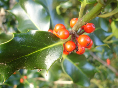
This picture best sums up today. The trees are now in a partial or total state of undress but after a horribly wet and windy few days, it's now unseasonably warm and sunny.
Distance: 9m
Walked: 15/11/09
For reasons of time I cut out some of the less nice paths and ended up with a cut-down 'lite' version of my '3 viewpoints' walk. (Missing out two of the original viewpoints!).
The first alteration was to cut off Bardon church and use a beautiful path from Burney Lane (just past Scotland Farm) to Melbourne.
The next alteration was to turn left at Robin Wood and head directly to Ticknall, using another very pleasant countryside path.
Holly berries are out! Jollymerry.
Click the map to view on OS Explore.
Sunday, November 15, 2009
Monday, November 02, 2009
What's to see in November?
This new (to me) camera has been a life-changer. On this breezy but bright November day, rather than tread many miles at a purposeful pace, I spent a couple of hours covering half a mile through some woods and back. Rather than face forward and concentrate on the route, I looked around and found many interesting things.
I did visit this particular woods because I went astray here while walking the Ivanhoe Way last time, and wanted to make sure I knew the correct route ready for next time.
The most noticeable things about November are the green turning brown, trees turning bare and the ground becoming covered with a carpet of bronze leaves.
The dry pods of this broom are beautiful in macro.
The bracken is turning brown.
More bracken? No, this is moss in extreme close-up. Frondy.
These guys were tiny:
There are more new photos in my Autumn Colour set over at Flickr.
Sunday, October 11, 2009
Autumn Colour at The Heart of The National Forest
Walked: 11 October
Distance: 10 miles
Summary: Starting from The car park at the bottom of Gorse Lane, Walk to Albert Village and around the lake. Cross the road and through Diana Memorial Woods and Tunnel Wood. Along the railway line to Oakthorpe, to Willesley, Boothorpe and back to the start.
This will be a nice walk to do in the murkiest depths of winter because much of it follows well-surfaced paths.
Today, though, I wasn't really fired up by the walking or the route, but fired up by the autumn colour and by the new (to me) camera that has arrived in the post. To be honest, it's battered and not very new, but it's so much better than my old one and I had to try it out! And what amazing colour there is out there at the moment.
I started close to Albert Village, simply because I pass this tree on my way to work every day and can't believe the colours it's turned:
I was pleased to see these black spots on the sycamore - it's said to be an indicator of air quality (the fungus causing it doesn't thrive in urban areas) and is part of the natural life cycle of the leaves.
Putting the macro through its paces was fun!! And there are so many beautiful things around to get up close to... rosehips, hawthorn berries, elderberries and even some blackberries left. (They were delicious!)
More photos on Flickr:
http://www.flickr.com/photos/shieladixon/sets/72157622438095679/
Click the map below to find an interactive version on OS Explore. Find your way around the route with an even more detailed OS Explorer 245 (The National Forest)
Wednesday, September 23, 2009
South Derbyshire 18
Walked: 16/9/09
Distance: 16 miles
Summary: A walk around South Derbyshire taking in some wonderful views. Starting at the Ferrer's Centre, which provides convenient free parking, through the Calke estate and Ticknall, around Robin Wood and the Foremark Reservoir, Daniel Hayes Farm, Smisby and a little section of the Ivanhoe Way. Finally a rest beside the beautiful lake at Staunton Harold Hall.
A different Start point and slight adaptation makes this a slightly shorter route than the last time I walked it. The Ferrer's Centre provides free and convenient parking. The first three pictures here were taken at roughly the same spot (by Robin Wood). No apologies, it's a great viewpoint and the sun was obliging enough to make the scenes look even better.
A lovely sun-dappled path.
This photo (apologies for the orientation) is of Himalayan Balsom. There's quite a lot of it along this part of the route. It's an invader and there are efforts to stamp it out, although I expect they'll be futile. It raises the question of whether if something finds its way here and thrives, then should it be allowed to flourish? Surely that's nature in action? And a bit hypocritical if we decide that it shouldn't be allowed to thrive at the expense of native species. (I'm thinking of Europeans in America and Australia).
This is one of the changes to this route since last time I walked it. Instead of walking by Bondwood and through the woods past Carvers Rocks, I took the bridleway a little bit further on:
This is the day's big surprise. I noticed a nice high point close by, and then noticed that there are new picnic benches at the top. On investigation, I found that it's a new area of National Forest called Hartshorne Forest, and it has an amazing 360 degree view.
Although this walk just misses the spectacular high point at Daniel Hayes Farm, it's
I think this view of Smisby church is particularly picturesque.
There are a few of these lockups around the place. I think you'd end up in here if you were arrested drunk late at night. I don't know why we don't still use them?
Finally a rest beside the beautiful lake at Staunton Harold Hall.
Click the map below to see a detailed route map on OS Explore. Find your way around the route with an even more detailed OS Explorer 245 (The National Forest)
Sunday, September 20, 2009
Foremark Reservoir circular walk
Distance: 4m
Walked: 15/9/09
This is a short jaunt with some lovely South Derbyshire views. You'll see from the map that the start point this time is the 'proper' car park at the top end (just outside Ticknal) and walk anti-clockwise around the reservoir. Unfortunately, there's no way to avoid a little bit of road, but we soon join the sandy lane which travels the western side of the reservoir. Half-way along this are some views across the water.
It emerges at a road. This point is certainly one of South Derbyshire's finest viewpoints. Whether you can call the cooling towers and Toyota factory landmarks or eyesores is your choice.
After Bondwood farm, a path crosses horsey fields and takes you down into the woods, past Carvers' Rocks before emerging at this secret picnic spot at the bottom of the reservoir.
This very straight bridleway takes you back to the start point. An alternative is to pick your way through the woods between this path and the water.
Click the map below to see the interactive version on OS Explore.
Saturday, September 05, 2009
Staffordshire circular
Walked: 31 Aug 2009
Distance: 23 miles
I think this is the fourth time I've walked this route, and three have been on August bank holiday. Maybe it's unimaginative to get stuck into such a habit, but I find the routine comforting. It's a route that has much wild fruit; blackberries, apples, damsons, and these are ripening at this time.
This time, I tried parking at Shobnall Leisure Centre, Burton on Trent, It is convenient and free parking for this walk.
The first part of this route takes the Trent and Mersey Canal for some pleasant and easy walking.
It picks up the Millennium Way, which is waymarked, but some careful navigation is needed. We part company with the MW just through Yoxall. Cross fields to Hadley End, then road to Hoarcross, then Newchurch. More navigation across fields to skirt Hanbury and Tutbury.
Previously, I'd used more footpaths to keep off the roads, but this time took a few roads to save time. That's how I found this Roadside Verge Nature Reserve - the sign says that it's managed for its wildlife. I find this a bit of an oxymoron - surely wildlife is best managed by not managing it, ie leaving it alone, if you see what I mean! I still welcome this initiative and would love to see more.
If you have time it's worth taking a detour to the crater at Fauld, the result of a large accidental explosion during the war. Enjoy the view of Tutbury Castle, then head south to Anslow and back to Shobnall. The splodge in the middle of the picture is a drop of coffee - I perched on a stile to take the photo and drink coffee, but
Hops are not as delicious as the beer that they are used to make. I enjoy spotting them in the hedge because I like the way they look and they're not very common.
This is a curiousity. This is certainly an elder bush and is full of berries, but strangely also some flowers...
After nearly 23 miles, Burton is a welcome sight!
To see details of the whole route, please click the map below to visit my page on OS Explore. It won't give you the detail of a 1:25,000 (Explorer) map. This route is covered by Explorer 245
Distance: 23 miles
I think this is the fourth time I've walked this route, and three have been on August bank holiday. Maybe it's unimaginative to get stuck into such a habit, but I find the routine comforting. It's a route that has much wild fruit; blackberries, apples, damsons, and these are ripening at this time.
This time, I tried parking at Shobnall Leisure Centre, Burton on Trent, It is convenient and free parking for this walk.
The first part of this route takes the Trent and Mersey Canal for some pleasant and easy walking.
It picks up the Millennium Way, which is waymarked, but some careful navigation is needed. We part company with the MW just through Yoxall. Cross fields to Hadley End, then road to Hoarcross, then Newchurch. More navigation across fields to skirt Hanbury and Tutbury.
Previously, I'd used more footpaths to keep off the roads, but this time took a few roads to save time. That's how I found this Roadside Verge Nature Reserve - the sign says that it's managed for its wildlife. I find this a bit of an oxymoron - surely wildlife is best managed by not managing it, ie leaving it alone, if you see what I mean! I still welcome this initiative and would love to see more.
If you have time it's worth taking a detour to the crater at Fauld, the result of a large accidental explosion during the war. Enjoy the view of Tutbury Castle, then head south to Anslow and back to Shobnall. The splodge in the middle of the picture is a drop of coffee - I perched on a stile to take the photo and drink coffee, but
Hops are not as delicious as the beer that they are used to make. I enjoy spotting them in the hedge because I like the way they look and they're not very common.
This is a curiousity. This is certainly an elder bush and is full of berries, but strangely also some flowers...
After nearly 23 miles, Burton is a welcome sight!
To see details of the whole route, please click the map below to visit my page on OS Explore. It won't give you the detail of a 1:25,000 (Explorer) map. This route is covered by Explorer 245
Subscribe to:
Posts (Atom)