Saturday, September 29, 2012
South Derbyshire Three Viewpoints Walk
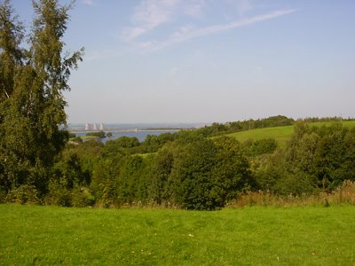
One benefit of the rainy weather we've had this year is that the water levels are nice and high.
This is one of the first, if not the first, that I devised and I've walked it many times. It felt good to tread the 14 miles of South Derbyshire again today, I have neglected my hobby this year, a downside of the rainy weather!
More pictures from today's walk are here on Flickr
And more information about the route including a map is here at uk-walks.info
Thursday, March 13, 2008
Ouch!
Distance: 24 miles
I'm walking as if I've just got off a horse. A couple of weeks ago I did 27 miles over two days and so thought that I'd manage 22 with no problems. Once out there, I couldn't resist a detour to see Anchor Church Caves which boosted the distance a little, and the last couple of miles were a little bit tortuous.
First thing this morning, when I left the house, there was a hint of spring in the air. It was early, but the sun was high, Despite the chilly air, it didn't feel quite so wintry. This feeling didn't last long, The sun stayed out for half of the day, but the air was chilly. Note to self - During March, it's worth taking gloves - they're not too heavy to carry if you have to take them off.
The weather deteriorated during the day. Towards the end, the sky was decidedly heavy.
Some good nature watch photos today. Things are starting to creep out blinking into the sunlight.


This chap was quite tame and let me take lots of photos quite close.

This was quite a common and wonderful sight today - the green is hawthorn and the white is blackthorn (yes, really). The former is one of the earliest leafing shrubs, but the flowers don't come out till later (May, which is why it's sometimes called Mayflower). Blackthorn comes out in flower first before it shows its leaves.

Oops - sideways. Unless I'm mistaken, these are fairly fresh deer tracks (and the odd bootprint).

I couldn't resist recording this woodpecker doing its thang. The views here are great too - just past Anchor Church you climb up quite high and have a good view over the river.
This is the bridge over the Trent between Willington and Repton. A lovely bridge, and one of few crossing points. The impressive spire of Repton church is in the background.

These caves are known as Anchor Church - read back through this blog for more info.

Sunny South Derbys 12
Distance: 12m
We just needed a local 12 miler to walk up an appetite for dinner. A variation of my 3-viewpoints fitted the bill. Daffs are out - yay.
Monday, March 10, 2008
Three Viewpoints again
- Walked: 24 February 2008
- Distance: 14m
- Terrain: some inclines
- Summary: Starting from the Severn Trent car park close to Dimminsdale, head for Breedon Church (first viewpoint). Via Melbourne through Robin Wood to Foremark Reservoir. Pause where the wicker Jack and Jill used to be and the abandoned car park at the South of Foremark Reservoir (second viewpoint). Back via Pistern Hill.
- Time: 5.5 hours start to finish
- Notable views: See above - plus the view back over South Derbyshire from the trig point just before Robin Wood.
I've walked this route a few times now. any route looks so different at different times of the year. Today was a bit dull and grey at times, but leaves and buds are starting to appear. I find this such an optimistic time of year.


An interactive route map, GPX file (for loading into your favourite mapping or navigation app) and more details are all at https://uk-walks.info/viewpoints_walk.html
Saturday, November 17, 2007
3-Viewpoints Mark 2
- Walked: 17 November 2007
- Distance: 14m
- Terrain: some inclines
- Summary: Starting from the Severn Trent car park close to Dimminsdale, head for Breedon Church (first viewpoint). Via Melbourne through Robin Wood to Foremark Reservoir. Pause where the wicker Jack and Jill used to be and the abandoned car park at the South of Foremark Reservoir (second viewpoint). Back via Pistern Hill.
- Time: 5.5 hours start to finish
- Notable views: See above - plus the view back over South Derbyshire from the trig point just before Robin Wood.
I devised this walk a couple of years ago as a 'mystery walk' for friends. I've since walked it several times.
Today I tried a slightly different start and finish. I've never liked walking through Calke park because of the number of people. I started at the Severn Trent car park close to Dimminsdale Nature Reserve. That meant that I could finish via South Wood and the Ivanhoe Way. Much better.
The walk starts with a little bit of road, but the new start point means that there's less walking on the road. After about a mile you get your first view of Breedon Church. It looks a long way away at first, but it's surprising how quickly you arrive at the top of the hill. There's a golf course to cross before arriving in Breedon and the foot of the hill.

I've taken this picture lots of times before, but it really is a lovely church, and the view is good, although still a little hazy when I was there today. It's only 2.5 miles into the walk, but a lovely place to stop for coffee and cake.

After the church you have to walk across another golf course. I do feel out of place walking past the golfers, just as I suppose they would if they were walking across a ploughed field in their golf shoes with their golf club trolleys. There's a little bit of a climb before looking back to see this wonderful view. The church is in silhouette and the golf course I've just crossed is in the middle distance.

The town in the distance is Melbourne. I took this same picture last time I did this walk; there was a tractor ploughing the field ahead, and I had to walk around the edge. This time there is a path pressed diagonally across the middle, following the right of way.

This is Melbourne Hall, patriotically flying the St George cross.

After St Brides (some very old buildings) and Robin Wood, this track approaching Seven Spouts Farm was looking beautiful today.

There are some lovely views in this area. This is close to Hangman's Stone.

I've taken this picture several times before too. Lamont Wood (no doubt named after an ex-chancellor) is a favourite spot for lunch. The view over the Trent Valley is great today while the sun's out. This was around Midday, and the length of the shadows shows how low the sun is in the sky at this time of year. While I was eating, the sun decided to go in, and the temperature dropped. The rest of the day was grey, but this is well over half way now.

Another favourite viewpoint, looking over Foremark Reservoir from the southern point.

This is where my new part of the walk really starts. Instead of heading for Ticknall and Calke, I went south towards Daniel Hayes. There are some spectacular views from the top of Daniel Hayes, and so extending the walk a little bit could add another viewpoint! Today I just followed the track by the side of the hill. I'm baffled about why this part of the National Forest is called 'The Oaklands' when the trees are obviously conifers!

After Pistern Hill Farm, this is a track I'd not used before, and the view looks as if it could be very nice when the sun's out.

This is Dimminsdale Nature Reserve. This very scruffy bit of ground is where the most spectacular carpet of snowdrops appears in February.

This is the view from the southern point of Staunton Harold reservoir, close to the end of the walk.

Click the map below to see lots more photographs from today's walk (exported for web by the soon-to-be-released Meander v2).


The route and stats above were generated using Meander.
Image produced from the Ordnance Survey Get-a-map service. Image reproduced with kind permission of Ordnance Survey and Ordnance Survey of Northern Ireland.
Sunday, September 23, 2007
3 Viewpoints
- Walked: 23 September 2007
- Distance: 14m
- Terrain: some inclines
- Summary: Starting from the round car park to the south of Staunton Harold Reservoir (first viewpoint), head for Breedon Church (second viewpoint). Via Melbourne through Robin Wood to Foremark Reservoir. Pause where the wicker Jack and Jill used to be and the abandoned car park at the South of Foremark Reservoir (third viewpoint). Back past the Calke estate to the finish.
- Time: 5.5 hours start to finish
- Notable views: See above - plus the view back over South Derbyshire from the trig point just before Robin Wood.
I planned this route as a 'mystery walk' for friends 18 months ago and have now walked it several times, the last time being just over a year ago. (I seem to have taken half an hour less today. possibly because it wasn't as warm, and so stops were shorter!)
This is the view across the reservoir - the start / finish point.
The first thing I noticed today was the changing colours of the trees and shrubs. It makes the countryside look beautiful, but I find it faintly depressing, because it heralds months of darkness and cold.
When Bardon Church first comes into view it looks so far away but you do arrive at the foot of the hill quite quickly. You first have to cross this golf course, which always feels slightly perilous. It's quite a climb to get to the top of the hill, but the view is worth it. A good place for coffee and yurt cake, especially if you've forgotten to eat any breakfast as I had this morning. I've probably mentioned before that this church is well worth a visit for the large collection of Saxon carvings.
There's another golf course to cross before Melbourne comes into view. I noticed that the landscape had a real patchwork quilt look to it today. You can just about see a tractor in this picture, busy doing what tractors do. The footpath crosses this field. It's hard work crossing a ploughed field, not to mention the risk of being run over by a tractor or being covered by what it was distributing, so I took the safer route around the edge of the field.
This trig point marks one of my favourite views in South Derbyshire. I've never managed to take a convincing picture, but we're looking down on the Trent Valley. I recently heard someone complaining that if you are driving from Ticknall to Swarkestone, there's nowhere to stop and take in the view. I wanted to call that person a lazy so-and-so, because this point is only a very short walk (half a mile) from Ticknall. Making an effort to get there makes you appreciate the view so much more. The history lesson on the trig point is a bonus! (I think I've published a close up of the text in another post - better still get out there and find it!)
Lamont Wood by Foremark Reservoir is a great spot for lunch, again looking down on the Trent Valley. Not such a nice day as it was in September last year when I took this same photo. The boots weren't looking great then, and they have walked 320 miles since (yes, I've been through my posts and added up the miles!) The boot manufacturers aren't queuing up to sponsor me, and I'm not sure how many more miles these ones have in them.After lunch, continue along the reservoir, and head for Calke. I'd previously resolved to find a better route back to the car park, avoiding the Sunday crowds in the grounds of Calke Abbey. The green line on the map shows the route I tried today, which worked well. It involves a longer walk along the road just before the end, but it's much better.
An interactive route map, GPX file (for loading into your favourite mapping or navigation app) and more details are all at https://uk-walks.info/viewpoints_walk.html
Monday, September 11, 2006
3 Viewpoints
- Walked: 10th September 06
- Distance: 14m
- Terrain: some
- Summary: Starting from the round car park to the south of Staunton Harold Reservoir (first viewpoint), head for Breedon Church (second viewpoint). Via Melbourne through Robin Wood to Foremark Reservoir. Pause where the wicker Jack and Jill used to be and the abandoned car park at the South of Foremark Reservoir (third viewpoint). Back past the Calke estate to the finish.
- Time: 6 hours start to finish
- Notable views: See above - plus the view back over South Derbyshire from the trig point just before Robin Wood.
- Notes to self: Find a path back to the car park avoiding Calke Park.
I planned this route as a 'mystery walk' for friends at the beginning of the year and have now walked it several times. This time we started in heavy mist, which soon cleared to reveal the most glorious September day. There were still some blackberries on the hedges, and as a bonus, we found a conference pear tree with ripe fruit!! (I'm keeping the location to myself!!) The description below is not intended to guide anyone around without Explorer 245 and the ability to read it!
The first viewpoint is the start / finish point - the round car park to the south of Staunton Harold Reservoir (which Ordnance Survey have marked as a viewpoint). The first mile is unfortunately along roads, but they're quite quiet, especially first thing on a Sunday! Head back along the road, (past an eye-catching newly-thatched cottage roof) and turn left at the bend to pass Dimminsdale Woods (which is noted for its carpet of snowdrops early in the year, and old lime kilns a few yards from the road - worth a look) and cross the valley bottom. Follow the road to Scotland farm, SK388222. Follow footpaths which take you in pretty much a straight line across fields and a golf course towards Breedon church. Unfortunately this time, we started off in fog, and so we had to peer through the mist to see the outline of the church on its curious bump of a hill:
Paths bring you out on the road at the entrance to the golf course and, a little further, a garden centre which has a tearoom and loos. As you start to climb the hill, the ground is open access land. There are several paths which take you up and back down the hill. Because it's such a steep climb, you find yourself at the top surprisingly quickly! The aforementioned fog had started to clear by the time we reached the church and so although the view from the top of the hill (which includes Donington Racetrack and East Mids Airport) was a bit poor we had this great view of the church itself:
It's well worth making time to look inside the church itself - it is home to a wonderful collection of Saxon stone carvings. When you've finished, leave the top of the hill by finding the path to the north-west of the church. You'll cross a road half-way down and then come out on a tarmac road at the bottom. Walk north along this road just a short way to find the very well-marked path across another golf course. Follow paths in pretty much a straight line which take you over a ridge and down into the historic and beautiful Melbourne.
Pick up the footpath at SK375249, which takes you past St Bride's and a trig point which has a plaque on it which tells you all about it. (This photo of the trig point was taken last winter). Turn around and look behind you - the view from this point is worth a look.
The path which goes directly through Robin Wood is the muddiest quagmire that I know, and is muddy even in the driest weather. In the winter it's worth finding another way around. We hadn't had lunch at this point, and I'm pleased that we held off as we passed Seven Spouts Farm, Hangman's Stone and Bendall's Farm, because the picnic spot in the new Lamont Wood (approx 337245) was perfect; secluded and affording good views:
There used to be a 'wicker' Jack and Jill on this path towards the bottom end of the reservoir. If anyone knows what happened to them, please let me know. Their wishing well is still there (although a bit overgrown) and this is the third viewpoint. In fact, the view over the reservoir from the picnic spot just a little further on is well worth a look:
You'll find yourself in an abandoned car park - permanently locked. I have heard that this is because of night-time misuse, but I'd like to have some confirmation of this. It's actually quite fascinating to see nature reclaiming this area - moss growing over the tarmac and grass coming through it.
If time and legs allow, do locate Carver's Rocks, especially if you like a scramble. It's good fun climbing up the rocks.
The footpath brings you out on the Hartshorne -> Ticknall road. Cross and find the path which takes you past the Scaddows Farm, and then across to the Calke Park. There's a gap in the boundary wall at approx SK358230 which on this occasion we took, headed in a straight line past Betty's Pond and through the nature reserve. We've taken this path a number of times, but you do find yourself among flip-flops, push chairs and old folks with very small dogs. Being a solitary kind of person, I've resolved to find another way back to the round car park!
An interactive route map, GPX file (for loading into your favourite mapping or navigation app) and more details are all at https://uk-walks.info/viewpoints_walk.html