Sunday, March 01, 2009

Green shoots

Distance: 11m
Walked: 1 March 09

I've really let my walking slip. It's difficult to get motivated during the winter. But this morning, officially the first day of Spring, that changed. Contrary to the weather forecast, the sun was out and it really did feel like Spring. Seeing a few buds and leaves really did get the juices flowing again! this is Hawthorn, one of the first signs of Spring.


Here we hit a minor snag. That underwater stile and waypost is where the public right of way is. It hasn't been raining, and so this strange flood seemed odd. We couldn't see any reason for it (for example a blocked river), it was just a flooded field. Even more bizarrely, the water is marked on the map (and the dotted green line of the footpath goes through the water), so it seems to be reasonably permanent. Presumably it wasn't flooded when the waypost and stile were put there...? Fortunately, it wasn't too difficult to take a slight detour around the edge of the water.


A classic image of spring. Wool on legs.


I haven't identified this tree yet, but it has big pom-pom-like catkins with busy bees all over it.


Bakewell to Monsal Head

Distance: approx 6m
Walked 8 Feb 09

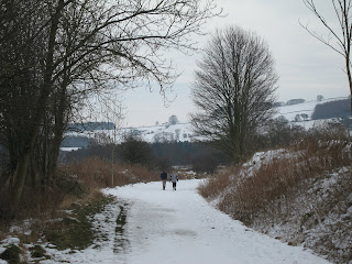
The Monsal Trail is an old railway line. They're often nicely-surfaced and great for walking at this time of the year - flat and not muddy. The snow today did make the veiws incredibly picturesque, and gave us the opportunity to warm up with a game of snowballs, but the price for that was that it was very slippery.


Monsal Head has to be one of the best views in the Peak District. All the better for being a little unexpected. The viaduct, which originally carried a railway, but is now a surfaced walking path, is fascinating. Imagine the valley without a viaduct, and then imagine someone proposing to build one across the valley. John Ruskin had a real rant about it, and he's quoted on an information board. his main beef seemed to be about making it easier for humans to get (unnecessarily) between Buxton and Bakewell. Ironically, the viaduct is now protected. I did find myself sympathising with the old curmudgeon; the viewpoint that this picture was taken from is a car park, so you can drive up, enjoy the view, enjoy a pint and drive home again. It's lucky that Ruskin couldn't forsee that. I can't help feeling that you should have to work for a view as good as this.

Once we'd arrived at this point, we made a little loop by walking (very tentatively) down to the viaduct (bottom left of this picture), over it, across the river where the buildings are on the right, and back up to this viewpoint again, before heading back to Bakewell along the railway line.

Monday, January 19, 2009

Rover Soar

Walked: 10 January 2009
Distance; 14.6 m

This walk starts at Diseworth and crosses a few fields before hitting Long Whatton. This is the intriguing church there. Usually, a church has a central original aisle, often with an aisle each side added later. Note that the tower here is not part of the central aisle, but the one that's to our right. I'm very curious about this asymmetry - was the tower added later and for some reason couldn't be added to the central part, or is the right-hand part with the tower the original part, and the two parts to the left added later?


After quite a bit of road walking, we arrive at the River Soar. The route of the river and our walk get a little bit convoluted here. The river flows behind us and in front of us, but we carry on walking along the road for a little bit, cross a field and join the Zouch Cut (a canal) before starting to walk along the river. The point where the cut joins the river is in the middle distance of this picture.


This is the cut. Notice the broken ice on the water. I had high hopes for the weather today but unfortunately this greyness was with us all day.


Anyone who knows me will know why I squealed with delight when I saw this boat:


We had thought of carrying on along the river, but we knew we wouldn't have the daylight and weren't prepared for a night walk. Therefore, we worked out a route which would get us back before dark, leaving the river here and going through Kegworth.


We approach the East Midlands Airport. We're right under the flight path here, and looking back at Kegworth.


Just before the airport, we arrived at the M1 motorway. On the bridge we used to cross the motorway we found this plaque and floral tribute. If you enlarge the picture you may be able to read the wording. It's for the people that died 20 years ago when a plane fell short of the airport and crashed on the motorway.


This is the motorway today. With airplanes coming in to land overhead, it was chillingly easy to imagine the crash scene.


There's no avoiding walking along the motorway for a little bit. This path actually goes parallel with and between the M1 and A453 - this path looks pleasant, but the noise isn't very relaxing! It's just a short stretch, before we cross the A453 and head towards the airport. It was already quite dark and so no more photos.


This walk goes quite close to Castle Donington. Today we avoided the town itself, and headed for the Airport perimeter. Although that's not a public right of way, the Airport authority have marked out the perimeter (and beyond) as a walking path. (For legal reasons, they have to close it for one day per year - I can't remember exactly, but I think it's late November.) There are leaflets describing the Airport Walk. For us today, it was a very convenient way to join us up with public rights of way south of the airport which will take us back to diseworth.

Wednesday, January 07, 2009

Weaving around Norfolk

Distance:13m
Walked: 31 December 2008

Weaver's Way is a 60-mile Norfolk walk partly based on an old railway line. the full route meanders south-west from Cromer taking in Aylsham, North Walsham, Stalham and goes on to Yarmouth via the Broads. The name reflects the historic importance of the weaving industry to the area.

While visiting Norfolk, I made time to walk a part of the way; North Walsham through Stalham and on to Hickling. The sunshine and frost made the views beautiful and there were still plenty of rosehips to give some colour.


The Way is marked very well with finger-posts and discs (The green disc has a tiny map of the route marked on it!) However, as always, it would be a mistake to rely on these markers because it only takes one missing post (or for you to fail to spot one) for you to be lost. With the OS Explorer map in your hand (or print some off using the OS get-a-map service) you'll stay on track.

Meeting Hill is very pretty, and despite growing up in this area, I think this is the first time I've walked through. I think the name comes from the fact that non-conformists had to have their religious meetings outside the parish and this was the location of their meeting house.


After walking out of north Walksham town, there are a couple of fields to cross before picking up the old railway at Bengate.


The flat and straight nature of this section gives you the clear impression that it's an old railway, but just in case it isn't obvious, there are platforms and bridges.


One highlight was walking past Sutton Mill. This old windmill made us all wish that we had the cash to buy and restore it! There's a museum in the buildings at its base, but sadly it seems to have closed.

Thursday, December 11, 2008

By the light ... of the silvery moon

Walked: 10 December 2008
Distance: 7.5m

I've been wanting to go out walking at night for some time. It's happened by accident a couple of times, and I've enjoyed it. Tonight was reasonably clear and the moon was very nearly full.

I discovered that my old camera isn't up to taking good night-time photos. To the eye, there was plenty of light to see by, but all of my photos have just come out as black squares.

This is the only one that is usable. The moon doesn't look half as beautiful here as it did at the time.


It was very rewarding. The moon looked beautiful, the towns and cities were clusters of orange lights, and the moonlight was bright enough to walk by. The light was amazing. My disastrous photography proved that it wasn't really as bright as it appeared to the eye. A strange monochrome though, that colour being mithril.

I'm not sure whether it was a bad idea to walk paths that I didn't know very well, or a great idea. Orienteering was a little more of a challenge than in daylight. This being a linear walk, I obviously walked the same route back, but in reverse. I didn't need the map on the return part of the walk, because I remembered the paths pretty well. I think this was because when I did have the map out, I had to try and memorise as much as I could, because after reading a map by bright torchlight, it was very difficult to see in the moonlight once more.

I picked up where I left off last time out - starting in Stanton and walking east to Castle Donington, trying to keep to the higher ground for the views over the Trent valley.


The route above was generated using Meander.

Image produced from the Ordnance Survey Get-a-map service. Map image reproduced with kind permission of Ordnance Survey and Ordnance Survey of Northern Ireland.

Saturday, December 06, 2008

The Long View

Distance: 11 miles (linear)
Walked: 6 Dec 08
Terrain: The steep ascents are worthwhile!

The local moggies like to laze on top of my garden shed and take in the great view over fields and The National Forest. I thought about this as I drove to my local farm shop this morning, which takes me over one of my favourite South Derbyshire viewpoints (SK365250). Why do animals and humans alike find it so rewarding to find a high spot and take in a long view?

It might have to do with defence - from this position you can see a predator or enemy coming hours before they reach you and fight them off much more easily.

This is all a bit irrelevant for us these days, but nevertheless it feels great to be up high and see a long way. I felt inspired to devise a new walk which would follow the high spots along the Trent valley.


A circular walk would be great - to the south of the valley, then crossing over and back on the north of the river. This would be a very long walk because points where you can cross the Trent are few and far between.

Today's walk was a bit experimental and I'll develop this route some more but it worked out very well. I started in Repton and headed East, making it to Stanton before having to turn around to get back before dark.

From Repton, there are a couple of paths taking you East - on the map there's the main green line, and a pink alternative. I tried both today (one out and one back) and preferred the latter - the green one is low in the valley and you can't see very much more than Willington Power station.

I've said before that the walk along the river between Foremark and Ingleby (passing Anchor Church caves) is one of my favourite spots. Today the path was flooded, as it often is after wet weather. Once before I took off my boots and waded through. Today I thought I could see a way up over the cave, which gave me a great spot for a picnic lunch. This was off the right of way and was probably trespassing, which I hope the landowner will forgive, so I can't recommend it. Instead, I recommend the alternative path (blue on my map below) through Foremark

This chap seemed to enjoy sitting up high enjoying the view too.


In the distance is Ratcliffe power station making its signature across today's amazing blue sky. I really don't like the short days, and we're very nearly at the shortest day, but it was a perfect day for walking. The air was fresh and clear as a bell and the sun was bright. Despite some puddles being frozen over all day, the air didn't feel very cold.


The white building flying the St George cross is the John Thompson at Ingleby, famous for brewing its own marvelous beer.


This time of the year, there is a little bit of colour if you look for it. Today I saw beautiful yellow gorse flowers and red rose-hips. Here they're both showing in front of a tree in wonderful copper foliage.


I used Meander for Mac to generate the route below. Click the map for a bigger version complete with all of today's photos.

Sunday, November 30, 2008

Early winter nature watch

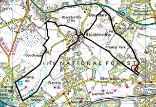
Route: Blackfordby figure-of-8
Walked: 30 November 2008
Distance: 8m
Summary: Starting at the Heart of The National Forest, Ashby de la Zouch, walk to Blackfordby, continue out to Woodville, then back in a loop to Blackfordby and a different Route back to Ashy (Possibly starting and finishing at The Beeches pub, well worth a swift visit).

I've broken a bit of a lull in my walking and made the most of the glimmer of sunshine which made it through the dull sky.

We're just three weeks away from the winter solstice, which here in the northern hemisphere means the days are almost as short as they're going to get. This, combined with me being short of spare time and letting my fitness lapse a bit, means that a shortish walk starting and finishing at my house was the order of the day.

I've written about my Blackfordby figure-of-8 walk before. It's one of my most regular South Derbyshire walks. The distinctive broach spire of Blackfordby church is in view most of the time. Today the church was looking a bit green and mossy.


In another life I'm bracing myself for Christmas Caroling season. It's not quite the bleak mid-winter yet, but 'The Holly and the Ivy' did seem very appropriate today. On the whole the trees and hedgerows looked pretty lifeless, but a few things were still keeping vigil, or in one or two cases, just coming into their own. Ivy looks pretty healthy and its berries are just starting to appear:


There's quite a contrast here between the brown and brittle bracken (to the left of the path) and the thriving holly on the right:


Surprisingly there are still plenty of red berries, including rosehips. These ones are among brambles (the blackberry bush) which are still green, but looking very tired and yellowing:


This bush was heaving with red rosehips, and looking really interesting, I thought, in silhouette against an attractive winter sky.


The route above was generated using Meander.

Image produced from the Ordnance Survey Get-a-map service. Map image reproduced with kind permission of Ordnance Survey and Ordnance Survey of Northern Ireland.

Saturday, October 04, 2008

Hadrian's Wall

[Brian is writing graffiti on the palace wall. The Centurion catches him in the act]
Centurion: What's this, then? "Romanes eunt domus"? People called Romanes, they go, the house?
Brian: It says, "Romans go home. "
Centurion: No it doesn't ! What's the latin for "Roman"? Come on, come on !
Brian: Er, "Romanus" !
Centurion: Vocative plural of "Romanus" is?
Brian: Er, er, "Romani" !
Centurion: [Writes "Romani" over Brian's graffiti] "Eunt"? What is "eunt"? Conjugate the verb, "to go" !
Brian: Er, "Ire". Er, "eo", "is", "it", "imus", "itis", "eunt".
Centurion: So, "eunt" is...?
Brian: Third person plural present indicative, "they go".
Centurion: But, "Romans, go home" is an order. So you must use...?
[He twists Brian's ear]
Brian: Aaagh ! The imperative !
Centurion: Which is...?
Brian: Aaaagh ! Er, er, "i" !
Centurion: How many Romans?
Brian: Aaaaagh ! Plural, plural, er, "ite" !
Centurion: [Writes "ite"] "Domus"? Nominative? "Go home" is motion towards, isn't it?
Brian: Dative !
[the Centurion holds a sword to his throat]
Brian: Aaagh ! Not the dative, not the dative ! Er, er, accusative, "Domum" !
Centurion: But "Domus" takes the locative, which is...?
Brian: Er, "Domum" !
Centurion: [Writes "Domum"] Understand? Now, write it out a hundred times.
Brian: Yes sir. Thank you, sir. Hail Caesar, sir.
Centurion: Hail Caesar ! And if it's not done by sunrise, I'll cut your balls off.

Distance of this circular walk: 7m
Walked: 27 September 2008

If there was any graffiti on Hadrian's Wall, which bounded the far corner of the Roman Empire, then it's long gone. As is the vast majority of the wall itself.

I have to take my hat off to the tourism people responsible for marketing the area, for getting so much value from something long gone. It's not fair to say that it's not there any more, because there are visible signs, but you have to look for them. On arrival at Greenhead near Gilsland (near Carlisle) I saw big letters on the side of a bus saying 'Hadrian's Wall Country'. It does all lead you to believe that there's a wall there to see and walk along.

To be fair, it's a well marked route, with plenty of information boards and bits and pieces to see and some glorious English countryside. I had just been expecting to see a wall - that's all!

Our starting point was close to Thirlwall Castle. Built long after the romans had gone, out of stones robbed from the wall itself, it's a fascinating piece of history. It marks a time of conflict, not between the Romans and those just beyond their empire, but between the Scots and English.


This route took us north-east; away from the route of the wall, but through some gorgeous scenery. The weather had looked dodgy (at best) when we set off, but as you can see it was superb for most of this walk.


Having turned south to join the river, footpaths took us back to Gilsland and the route of the wall. Our first sign of the wall was Poltcross Burn Milecastle, accommodation for about 60 soldiers or possibly prisoners. There's not much left, but the information boards show how (we think) it looked. The wall extended east and west from here.


This awesome arch, straight out of Lara Croft, is much later. The railway line runs over it.


This is what's left of the wall itself in this area. A bit of a mound and a bit of a ditch. Interestingly, you're asked not to walk in single file or worn bits of ground as an erosion measure. It's easy to see why a ditch and a mound like this is a good defence measure and puts those beyond it at something of a disadvantage. Even without the wall, it would be quite difficult to scramble over this lot with your sword in your hand and an enemy throwing things at you.