Saturday, May 26, 2007

Ticknall Leg-stretch

  • Walked: 23rd May 2007
  • Distance: 6.5m
  • Terrain: fairly flat
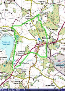
  • Summary: Foremark Reservoir using the straight bridleway, Calke Abbey, Ticknall
  • Time: 2 hours start to finish
  • Notable views: Looking back over the Trent Valley before Ticknall.


This is one of my most regular after-work walks. It starts on the long straight bridleway alongside Foremark Reservoir. Tonight it looked particularly green.


Something which really put a spring in my step was seeing elderflower for the first time this year. Just a bit longer, it'll all be out in flower, and I'll be back to collect some for this year's elderflower wine:


There aren't many flowers out right now, but this is the first poppy that I've seen this year:


This is one of my favourite spots. Just past Bendall's Farm and up a hill. It's marked on the map as Hangman's Stone. The drystone wall which I like sitting on is in the middle of the nettles on the left, so when in shorts as I was this evening, that's out of bounds.


This route continues to Ticknall via Seven Spouts Farm, through Calke Park (using the footpath parallel to the driveway) and across fields to Scaddow's Farm and back to start.


The route above was generated using Meander.

Image produced from the Ordnance Survey Get-a-map service. Image reproduced with kind permission of Ordnance Survey and Ordnance Survey of Northern Ireland.

Wednesday, May 23, 2007

Carver's Rocks and a Wishing Well

  • Walked: 20 May 2007
  • Distance: not far
  • Terrain: some inclines and the opportunity to scramble
  • Summary: Hartshorne to Carver's Rocks and Foremark Reservoir
  • Time: 2 hours overall
  • Springwatch: The may blossom and bluebells are all looking a little bit tired. There doesn't seem to be very much coming out in flower to replace them.

I've let things slip a little bit over the last couple of weeks, the longest day is rapidly approaching and I've got some serious work to do to build my stamina for the Ivanhoe Way. This weekend was another busy one, but Sunday was so beautiful that it would have been a sin not to get out in the sunshine.

Some ash trees are still coming out into leaf, but those that are a little more advanced now have flowers out:


Carver's Rocks is an ex-quarry. It's a lovely spot to sit and enjoy nature, or to try a scramble. There are a few places where you can climb without too much trouble or equipment, and other places where more serious climbers can use their ropes and things.


We enjoyed the sunshine for a while here before heading off to see what's left of the 'wicker' Jack and Jill. I still don't know the origins of this sculpture, but remember how awesome it looked when I first saw it. On a prominent spot and quite large, you could spy the figures and their wishing well from some distance. This is how they looked a few years ago: (Picture shows the figures but not their wishing well)


All that's left now is a very overgrown wishing well. The people themselves look to have been chopped down, perhaps when they became too overgrown. This is a real shame, and I'd love to see them replaced.


The spot is still one of my favourite viewpoints, and one of the viewpoints in my '3 Viewpoints' walk. The wire fence in the middle of this picture is where Jack and Jill used to stand:


The path which runs alongside the reservoir is a good path, and has been decked in places. It gives beautiful glimpses of the reservoir through the trees.

Saturday, May 12, 2007

May blossom

  • Walked: 6 May 2007
  • Distance: 16m
  • Terrain: some inclines
  • Summary: Packington, Normanton, Snarestone, Moira, Ashby
  • Time: 6 hours overall


This is the same route as Ivanhoe Way (part of) (part 1). I wanted to try it clockwise this time to see how how it felt - I can't decide which way round my attempt on the IW should be. If I did it clockwise, then the second half of this walk would be the last few miles of the full 36-mile walk.

This is one of the most colourful walks that I can remember. Along the way we spotted wisteria, laburnum, lilac, clematis of various colours, as well as fields of rape. This photo looks a bit grey and murky, but the flowers were so bright yellow that it hurt the eyes.


These bluebells were just by Swepstone church (see previous posts - the minister is Patrick Stewart) and not only do we have the albino white ones, but pink ones too - quite a display of colour.


Unfortunately, the weather wan't kind to us. It didn't bucket down, but the long wet grass has cunning ways of soaking your feet, even with Gore-Tex boots and gaiters! Actually, I think that my 'breathable waterproof layer' has been breached in at least one of my boots. If there's a boot manufacturer reading who'd like to sponsor my offensive on the Ivanhoe Way this year by providing a decent pair, then please let me know.
The trade off is the beautiful way that that the beads of water stood up on the grass like diamonds.


Measham has this intriguing mosaic sundial, which is a tribute to Joseph Wilkes. Note to self: find out who Joseph Wilkes was.


Absolutely everything is out now, in leaf if not in flower. I did have to shout 'Wakey Wakey!' at a few odd trees which were being a bit lazy. I noticed that they were all the same type, which I'm now sure is ash (see below). I'm sure Dive will put me right on this in the comments. Even the most reluctant of these were showing some signs of life. I've heard some talk on the radio this week about the old proverb "Oak before ash and you're in for a splash; ash before oak and you're in for a soak". This apparently helps you to forecast the weather, depending on which tree comes out first. As the oak seemed to have the head start, I assume that we're in for but a mere splash of rain in coming weeks, and I think we had most of that today.


Check out this fantastic may blossom, which almost obscured the green of some hedges.


This picture shows just how parched the ground is at the moment. Hard and cracked like crazy paving. This pic also shows how excellent some farmers can be at keeping the public rights of way open!


I'm still not sure which way to tackle the long walk. anti-clockwise means a very long slow climb at the end of the 36 miles, but this way means coming through Measham quite late in the evening - apologies to those who live there, but the tough climb does seem better.


The route above was generated using Meander.

Image produced from the Ordnance Survey Get-a-map service. Image reproduced with kind permission of Ordnance Survey and Ordnance Survey of Northern Ireland.

Friday, May 11, 2007

Caulkley Wood Bluebells

  • Walked: 29 April 2007
  • Distance: 4.3m
  • Terrain: some inclines
  • Summary: The best carpet of bluebells in South Derbyshire
  • Time: 2 hours start to finish


Last time out, I went in search for a spectacular display of bluebells, which I knew existed somewhere near Hartshorne, but didn't find them.

I've since found out that they're in Caulkley Wood, just north-west of Hartshorne. This Sunday afternoon stroll took us through that wood, and through some stunning countryside. If there's a heaven, and if I go there, this is the way I expect it to look.


The route above was generated using Meander.

Image produced from the Ordnance Survey Get-a-map service. Image reproduced with kind permission of Ordnance Survey and Ordnance Survey of Northern Ireland.