- Walked: 14th Jan 2007.
- Distance: 8.5m
- Walking time 5 hrs
- Terrain: flattish, muddy!
- Summary: From Swannington (north of Coalville), walk the 'inclined plane' dismantled railway, Osgathorpe, Belton and back via cycle path.
- map: Explorer 245
This is what remains of a 'rope-hauled inclined plane' railway, built by Robert Stephenson. This little bit of track has been left, with a few information boards standing around it.

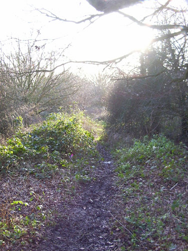
You can walk along the path of the dismantled railway, down the 1 in 17 incline, and then pick up the Ivanhoe Way. We decided that this was an old pumping station:

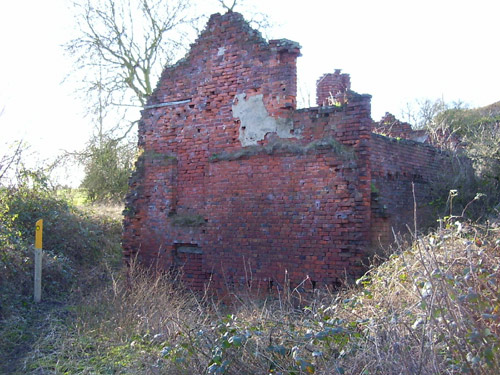
There are a number of tumbledown houses along this path, which give the feeling that you've gone to sleep like Rip Van Winkle and woken up in some post-apocolyptic world.

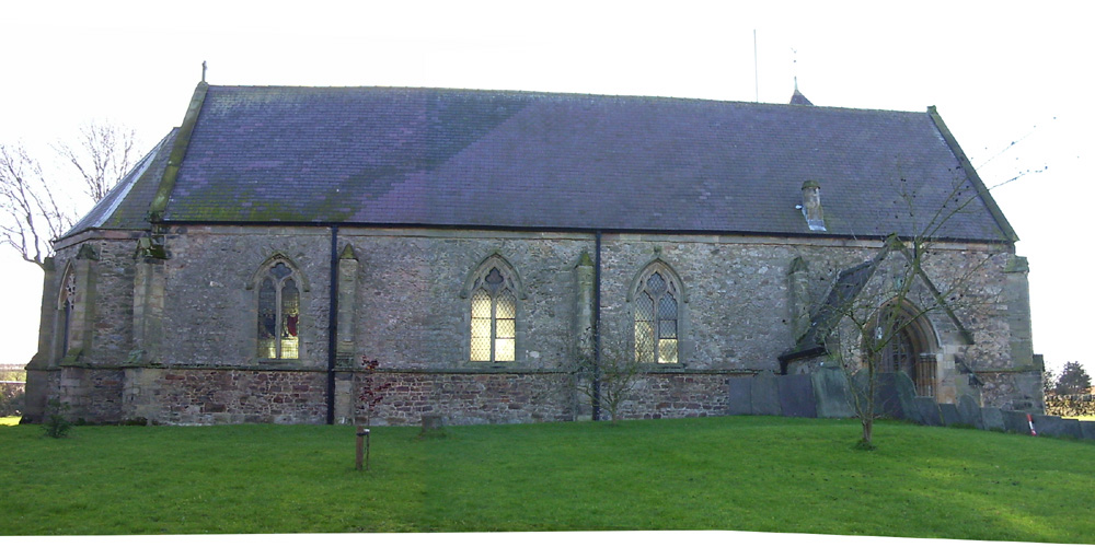
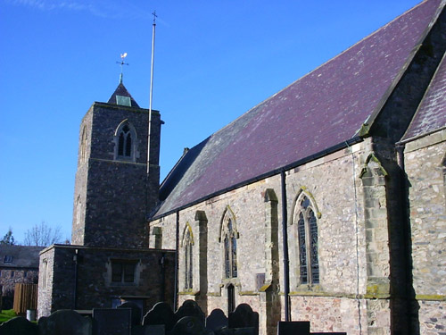
Osgathorpe is a great name, and sounds like the name of a bold Viking. This is Osgathorpe church, which is absolutely delightful. (I'm sure Dive can fill in some architectural details). I particularly liked the traditional weathercock on top of the tower.
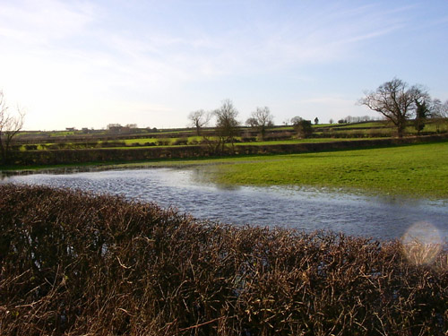
We'd had a lot of rain this week. I didn't realise just how much rain until we found ourselves almost knee-deep in mud, the paths between Osgathorpe and Belton were the worst.

We had planned to take footpaths out of Belton, but after experiencing the seriously boggy conditions, we decided that the cycle route would be a better idea. This shot shows just how wet some of the fields were.
After crossing the A512, the Grace Dieu Priory comes into view:

The cycle path follows another old railway line, although the tarmac path goes alongside the old railway. We found our way up to the dismantled line itself which was far more pretty.
We eventually meet the inclined plane once more, and follow it back to the car. This time it's uphill, of course, and I have to admit that 1 in 17 is steeper than it sounds!
Stats:

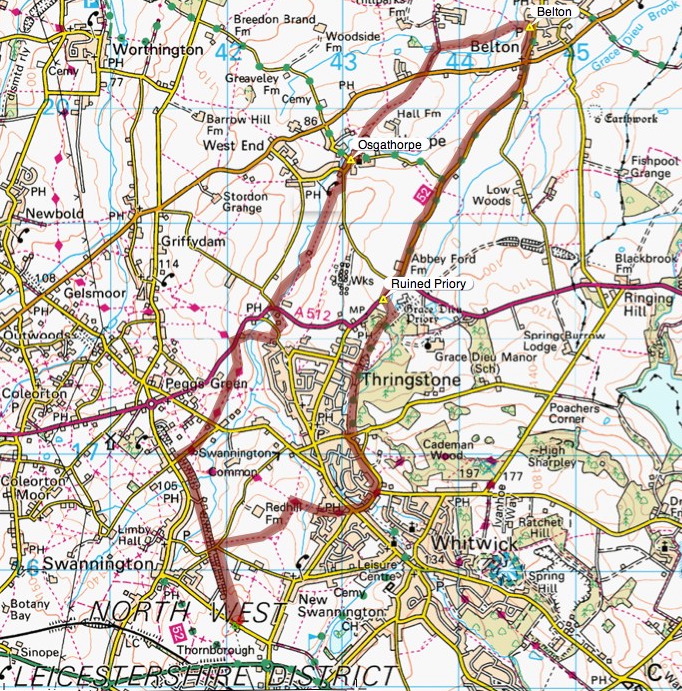
The route and distance statistics above were generated using Meander.
Image produced from the Ordnance Survey Get-a-map service. Map image reproduced with kind permission of Ordnance Survey and Ordnance Survey of Northern Ireland.


10 comments:
Wow, you have the best scenery for your walks.
My goodness, was just going to e mail to see where you were, when I see you have been rather busy!
Well done young lady... glad you are well, wish I was half as fit.....
Osgathorpe is indeed a great name, Peahen.
And its delightful church looks to be transitional Early Englsih to Decorated (from the window styles), putting its original construction from around 1220 to 1250 (I'm playing Mister Guessey here … Pevsner may well prove me a total asshat. Be a good girl and get a copy of Pevsner's Leicestershire from the library and check up for me, would you?).
Mind you, it's been cakked about with by those pesky Victorians so I doubt if much is left inside of the original.
The tower seems contemporary with the main building and is really cute as towers go.
Your original Stephenson railway is in much better repair than the Norwich to London main line.
All in all, another lovely walk. Hoorah for you and Rog.
Thanks Sassy. I'm of the opinion that too many people don't realise what beautiful scenery is on their doorstep.
Thanks B. Sorry to see you've had a bad back, hope it gets better soon. (Keep posting, it's a pleasure to see your beautiful handiwork).
You settle on a window (pun) of 30 years, 800 years ago, and call it a guess - you are funny! I could almost smell the victorians - that leftmost window in the long photo was brightly illuminated by the low sun shining through from the other side - it looks victorian (a safe bet when it comes to church glass) but it turned out to be later. There's lots more glass in the other side, and the whole church is in remarkably good repair and well-maintained. I would have liked a look inside (must go back another day) but we'd been up to our gaiters in mud, and it didn't seem appropriate!!
Hey Peahen nice photos of the country side - Thanks for sharing.
Hee hee.
I just put "Pevsner Osgathorpe Church" into Google to see if my date was close and the top hit was my quote on this post "Pevsner may well prove me a total asshat."
Google is fun like that.
The first records of the church are from 1224 apparently.
When I'm hot, I'm hot!
Well, Dive's hot then. I'm sorry it has taken me so long to get here. I love the tumbled down old houses.
I was driving home from a slight trip north yesterday and thought was dreary, brown, and miserable place our valley is this time of year. I would seriously hesitate to show any one pictures of it until spring. So the idea of seeing something lovely on my own doorstep won't work for me in January.
Thanks, Rich, nice to hear from you again. Did you ever get that Mellophone?
Dive - you're hot. I knew you wouldn't disappoint. That Google thing is great, in fact Google is great. To be able to keep on top of an index containing billions of pages, and keep it so up-to-date is astonishing.
Robyn - thanks for checking in. I find it difficult to believe that there's nothing beautiful around you at the moment, but you know best! Roll on Spring, as a wise man once said.
Hey, ho.
Someone pointed out to Lizzie and James that they own some legs and Mum pointed them at your blog.
Watch out! They intend to walk all over Leicestershire!
And "roll on Spring" is not something I need in my head, Spring Zhu being our China liaison officer and as pretty as Mao on a bad day.
Post a Comment