- Walked: 26th November 2006
- Distance: 8m
- Terrain: Some inclines
- Summary: Starting at the Heart of The National Forest, Ashby de la Zouch, walk to Blackfordby, continue out to Woodville, then back in a loop to Blackfordby and a different Route back to Ashy (Possibly starting and finishing at The Beeches pub, well worth a swift visit).
- Time: 2.5 hrs
This is one of my most regular short walks, I start from my home so no driving at all. We go via some National Forest, which is still very new in tree terms, but some of the trees here are now higher than a person. Almost from the start, you can see Blackfordby spire, which remains visible for most of this walk. The beautifully-shaped spire looks black in sillhouette from a distance, but as you can see from this picture, it is quite black:

When we came close to Woodville, we spotted these very strange low barriers. with buckets sunk into the ground. We guessed drainage, or barriers for rabbits or other animals. When we came to this waypost, the flapping sign on it told us that the barriers and 'bucket traps' are catching greater crested newts for 'translocation'. (What's wrong with the word relocation...? Or even eviction, come to that).
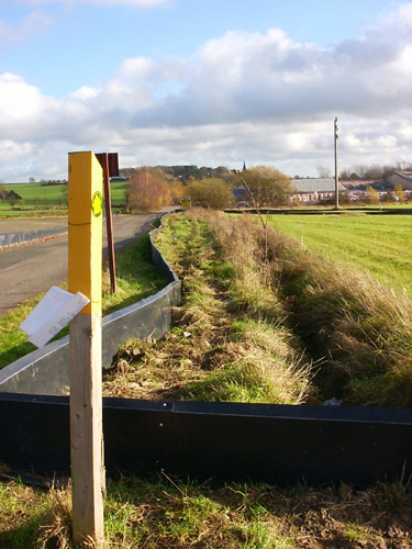
It seems that developers want to build lots of ugly buildings on quite a large area of this land, which is now quite beautiful. Hmmmm. However, there are some rare newts in residence, and so the developers are making a gesture by finding some and taking them somewhere else where they'll pine away.
These are views from Gorse Lane, the first at Boothorpe and the second just a bit further on:


You emerge on the road between Albert Village and Donisthorpe. It's not a very pleasant walk along the road, but it's not far. Look out for the footpath on the left, right at the bottom of the hill before the factories. The next section is very pleasant and gently rolling. The mining heritage of the area just isn't apparent any more... or is it? The hill on the horizon right in the middle of this picture is, we think, a slag heap from an open cast mine which we think may still be working:

We pass Blackfordby church once more, and go back to the starting point by a slightly different way, which uses the Burton Road back into Ashby. It's quite a busy road, but the views are great.
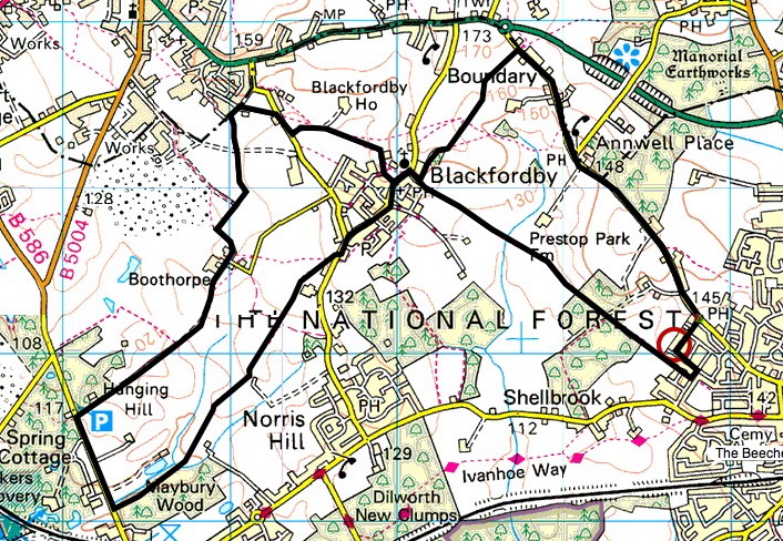
The route above was generated using Meander.
Image produced from the Ordnance Survey Get-a-map service. Map image reproduced with kind permission of Ordnance Survey and Ordnance Survey of Northern Ireland.


10 comments:
Aha! So that's the church we can see when we walk from your house up toward the bypass, is it?
Sad to hear about developers ruining yet another greenfield site when there are millions of acres of brownfield in the midlands.
And you're right about the newts: move 'em and they'll try and crawl back. They should wait for the spawn and move that. Then they should leave the field alone and bugger off and develop a brownfield site in town instead. Bastards (an architect's view of developers) …
I love the term "slagheap". Reminiscent of the crowds of binge-drinking teenage girls down Prince of Wales Road on a saturday night …
Y'mate Red Ken is a bit of a newt expert, isn't he? Perhaps I should write to him.
glad you didn't take the 'ugly building' comment personally - I don't know, but I'm assuming it'll be cheap corrugated industrial units or something, not one of your amazing girl's schools. in any case, what's there at the moment (aside from these wierd barriers) is far more beautiful than anything that the developers will put there.
yes, that's the spire. Despite being about 3 miles away, I can see it clearly from my bedroom window. Walking towards the bypass is generally in that direction. Several pages on the interweb call it a 'broach spire' - maybe you can enlighten us on what that means?
A broach spire is where someone plonks an octagonal spire on top of a square tower.
You don't get many reound our way; we've got mostly round Saxon and Norman towers. Though of course Norwich Cathedral spire is a broach spire, built when the Saxo-Norman one fell down in the big fire.
This looks like a lovely walk. Ohio was marked by canals over a hundred years ago--before railroads--and now these old trails are being converted into walking/biking trails. One will cross right through our town. Can't wait.
Canal paths are great, Robyn. They're dead flat because they follow contours, and it makes for a different experience from walking over less level countryside. Canal paths are better for covering more miles more quickly.
... and there's a lot to be said for starting and finishing a walk at your house. It doesn't seem quite right to drive somewhere before starting to walk...
You live in such a pretty part of the world.
My favourite walk from Peahen's house is down to the end of her street and across the main road into the rather good pub …
Mmm … Beer …
Translocation sounds as if they are being sent to America as punishment (poor bastards)
Nice walk and as I read i felt like I was taking a tour. Like the pics that go with it.
Post a Comment