Wednesday, November 29, 2006

Get Orf My Land.... or 8-mile figure of 8

  • Walked: 26th November 2006
  • Distance: 8m
  • Terrain: Some inclines
  • Summary: Starting at the Heart of The National Forest, Ashby de la Zouch, walk to Blackfordby, continue out to Woodville, then back in a loop to Blackfordby and a different Route back to Ashy (Possibly starting and finishing at The Beeches pub, well worth a swift visit).
  • Time: 2.5 hrs


This is one of my most regular short walks, I start from my home so no driving at all. We go via some National Forest, which is still very new in tree terms, but some of the trees here are now higher than a person. Almost from the start, you can see Blackfordby spire, which remains visible for most of this walk. The beautifully-shaped spire looks black in sillhouette from a distance, but as you can see from this picture, it is quite black:


When we came close to Woodville, we spotted these very strange low barriers. with buckets sunk into the ground. We guessed drainage, or barriers for rabbits or other animals. When we came to this waypost, the flapping sign on it told us that the barriers and 'bucket traps' are catching greater crested newts for 'translocation'. (What's wrong with the word relocation...? Or even eviction, come to that).


It seems that developers want to build lots of ugly buildings on quite a large area of this land, which is now quite beautiful. Hmmmm. However, there are some rare newts in residence, and so the developers are making a gesture by finding some and taking them somewhere else where they'll pine away.

These are views from Gorse Lane, the first at Boothorpe and the second just a bit further on:


You emerge on the road between Albert Village and Donisthorpe. It's not a very pleasant walk along the road, but it's not far. Look out for the footpath on the left, right at the bottom of the hill before the factories. The next section is very pleasant and gently rolling. The mining heritage of the area just isn't apparent any more... or is it? The hill on the horizon right in the middle of this picture is, we think, a slag heap from an open cast mine which we think may still be working:


We pass Blackfordby church once more, and go back to the starting point by a slightly different way, which uses the Burton Road back into Ashby. It's quite a busy road, but the views are great.
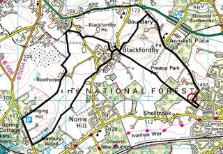


The route above was generated using Meander.

Image produced from the Ordnance Survey Get-a-map service. Map image reproduced with kind permission of Ordnance Survey and Ordnance Survey of Northern Ireland.

Monday, November 20, 2006

Shiela's Leicestershire 3-Peaks Challenge

  • Walked: 19th November 2006
  • Distance: 11.5m
  • Terrain: The clue's in the title
  • Summary: From the A511 between Coalville and Leicester, walk to Bardon Hill, then Beacon Hill, before returning via Billa Barra.
  • Time: 5.5 hrs
  • Note to self: Find out why the footpath at SK471131 has disappeared from the map!

The title of this walk is tongue-in-cheek, and based on the 'real' 3 Peaks Challenge. (In title only!) This walk was hastily-planned when we realised that the weather wasn't going to be as the weather forecast had suggested, very wet, but very pleasant and sunny. I've been up Bardon Hill and Billa Barra before, but it was with a squeal of delight that we realised that it would be easy to climb these two 'peaks', and make Beacon Hill too. We're only talking 250 metres high, but Leicestershire is a flat county. Bardon hill is apparently the highest point in Leicestershire.

There's a really useful lay-by at SK458120, on the A511 between Bardon and the M1. You have to walk back towards Bardon for a couple of hundred metres to find the footpath.

This is the real live genuine moat around Brook Farm:


Curling around to the left and picking up the Ivanhoe Way takes you to the top of Bardon Hill. This is the view from the top. Billa Barra, the third peak on this walk, is just about visible through the mist on the horizon in the middle of the picture.


Follow the road down and at the bottom, don't follow the footpath round to the left, instead, cross the track which is used by the quarry traffic and cut through to the tarmac road just beyond. At the farm, pick up the footpath. I'm not sure what's going on here, maybe a path has been moved, but according to the slightly older Explorer 245 we were using on Sunday, the right of way follows the power line to the road, skirting the ancient circular earthwork. On my more up to date Explorer, this path isn't marked, there's just the straight one joining Kellam's Farm and Upper Greenhill Farm. Hmmm.

We walk almost a straight line to a small road which goes beneath the M1. Follow some minor roads and footpaths to Beacon hill Country Park. It was disappointing to find that due to a car park close to the top of this hill, we were far from alone. A view this damn good deserves working for - not driving nearly to the top and doing the last few metres in fashionable heels!

My picture doesn't do the view justice. The strange wiggly lines in the sky are my hair, I think.


A short road walk before picking up footpaths again, through to Copt Oak. The radio masts there are good landmarks to head for. We cross the M1 once more. This is our premier motorway - remarkably quiet today:


Another bit of the Ivanhoe Way takes us back towards Billa Barra. I have to confess that we didn't finish the 'challenge' and make that third peak, due to a combination of cold, hunger, and being temptingly close to the car. This is that third peak with its intriguing crown of trees:


The route above was generated using Meander.

Image produced from the Ordnance Survey Get-a-map service. Map image reproduced with kind permission of Ordnance Survey and Ordnance Survey of Northern Ireland.

Friday, November 10, 2006

Revisiting Childhood

  • Walked: 10th November 2006
  • Distance: 2.5m
  • Terrain: flat
  • Summary: Park at honing, walk across common land and Weavers Way, then by road back to the start.
  • Time: 1 hr
  • Note to self: walk the Weavers Way again.


I remember walking the Weavers Way as a child. This short walk during a stay with the folks briefly revisits the disused railway.

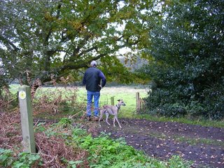
This is the area where my Dad grew up. Here he is with his dog:

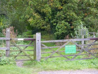
The path takes in a bit of the Weavers Way. On this walk, we leave the path here but it continues to Stalham and Hickling Broad.

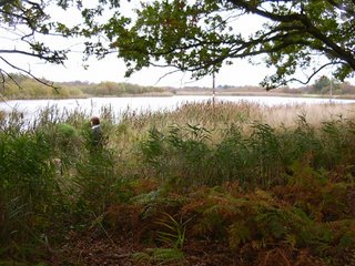
This beautiful piece of water is known locally as a 'scrape'. It was created by digging some ground out of a boggy area, in order to provide a duck hunting area.

The route above was generated using Meander.

Image produced from the Ordnance Survey Get-a-map service. Map image reproduced with kind permission of Ordnance Survey and Ordnance Survey of Northern Ireland.

Beach and Clifftop

  • Walked: 7th November 2006
  • Distance: 4.8m
  • Terrain: flat, with steep slopes up to cliff and Village.
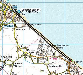
  • Summary: Park at Bacton, walk along the beach to Mundesley and back along the clifftop.
  • Time: 2 hrs
  • Notable views: All of it!
  • Note to self: investigate the Paston Way.


This is the first of two short walks taken with Mum and Dad during a week's holiday back in Norfolk visiting friends and family.

In November, these coastal villages are asleep. Some fantastic beach and sky views can be enjoyed almost alone!

Park at Bacton, walk along the beach to Mundesley. Climb the slope at the lifeboat station and into Mundesley. We enjoyed an out-of-season coffee and walked back down to the beach. At the lifeboat station climb up the slope and join the clifftop path:

Despite bits of the cliff continuously falling onto the beach, a right of way along the clifftop is maintained. The views are just fantastic, and explode the "flat Norfolk" myth!!

The route above was generated using Meander.

Image produced from the Ordnance Survey Get-a-map service. Map image reproduced with kind permission of Ordnance Survey and Ordnance Survey of Northern Ireland.